TF1.7 Boreal and temperate fens
TF1. Palustrine wetlands biome
TF1
Profile summary
Full profile at https://global-ecosystems.org/explore/groups/TF1.7
Brief description
Fens occur extensively in boreal-subarctic and cool temperate regions. Like peat bogs, with which they may form mosaics, they have waterlogged organic soils, but they are rich in mineral nutrients and typically neutral or alkaline in pH. The vegetation comprises a low diversity of small plants, fungi and brown mosses, but woody plants are generally absent. They support insects, specialised frogs and some birds. Shallow standing water or permafrost may be present.
Key features
Permanently groundwater-logged, nutrient poor to (moderately) nutrient-rich sites, often organic soils; high abundance of mosses, sedges and no to open woody species cover.
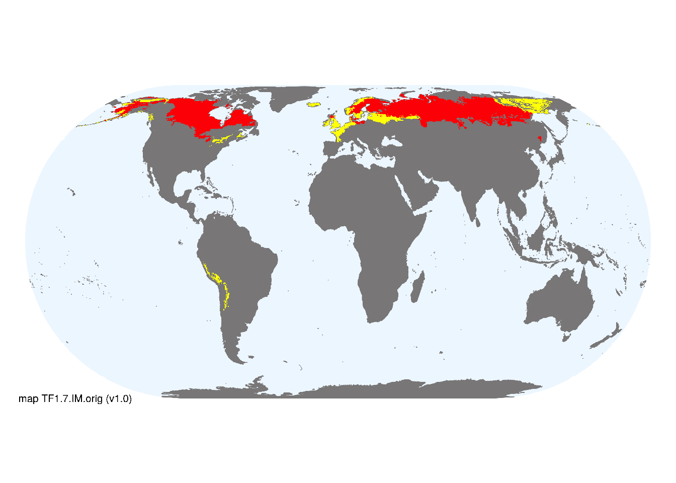
Overview of distribution
Boreal and temperate zones of the northern hemisphere, limited occurrences in the southern hemisphere (southern South America, southern Australasia, possibly South Africa).
Map description
Terrestrial ecoregions containing major or minor occurrences of this ecosystem functional group were identified by consulting available ecoregion descriptions (Dinerstein et al. 2017), global and regional reviews, national and regional ecosystem maps, locations of relevant examples, and proofed by expert reviewers. Consequently they are coarse-scale indicative representations of distribution, except where they occupy small ecoregions. Ecoregions were mapped at 30 arc second spatial resolution..
Map code and version: TF1.7.web.orig v1.0, available at ![]()
Version history
Profile versions
- v2.1 (2022-04-06): DA Keith; RT Kingsford; F Essl; LJ Jackson; M Kelly-Quinn; KR Young; T Tahvanainen.1
- v2.01 (2021-12-31): NA.
- v2.0 (2020-06-03): DA Keith; RT Kingsford; F Essl; LJ Jackson; M Kelly-Quinn; KR Young; T Tahvanainen.
- v1.0 (2020-01-20): DA Keith; RT Kingsford; F Essl; LJ Jackson; T Tahvanainen.
Available maps
Read more details about the current map versions here.
- Web navigation (code: TF1.7.web.orig, version v1.0)

- Indicative Map (code: TF1.7.IM.orig, version v1.0)
Read more details about older or alternative versions of maps for this functional group.
- Web navigation: in preparation (code: TF1.7.WM.nwx, version v1.0)
References
Main references
References used in the different versions of the profiles.
- Godwin KS., Shallenberger JP, Leopold DJ, Bedford BL (2002) Linking landscape properties to local hydrogeologic gradients and plant species occurrence in New York fens: a hydrogeologic setting (HGS) framework Wetlands 22: 722–737 DOI:10.1672/0277-5212(2002)022[0722:llptlh]2.0.co;2
- Wieder RK, Vitt DH (2006) Boreal peatland ecosystems Ecological studies vol. 188. Springer-Verlag, Berlin
Map references
References used in the different versions of the maps (current and discarded).
- Dinerstein E, Olson D, Joshi A, Vynne C, Burgess ND, Wikramanayake E, Hahn N, Palminteri S, Hedao P, Noss R, Hansen M, Locke H, Ellis EE, Jones B, Barber CV, Hayes R, Kormos C, Martin V, Crist E, Sechrest W, Price L, Baillie JEM, Weeden D, Suckling K, Davis C, Sizer N, Moore R, Thau D, Birch T, Potapov P, Turubanova S, Tyukavina A, de Souza N, Pintea L, Brito JC, Llewellyn Barnekow Lillesø JP, van Breugel P, Graudal L, Voge M, Al-Shammari KF, Saleem M (2017) An Ecoregion-Based Approach to Protecting Half the Terrestrial Realm, BioScience 67: 534–545. DOI:10.1093/biosci/bix014. Data-set available on-line
- Thomas Gumbricht Rosa Maria Roman‐Cuesta Louis Verchot Martin Herold Florian Wittmann Ethan Householder Nadine Herold Daniel Murdiyarso (2017) An expert system model for mapping tropical wetlands and peatlands reveals South America as the largest contributor Glob Change Biol. 23: 3581– 3599 DOI:10.1111/gcb.13689
Footnotes
This is the current version available at official site.↩︎