TF1.4 Seasonal floodplain marshes
TF1. Palustrine wetlands biome
TF1
Profile summary
Full profile at https://global-ecosystems.org/explore/groups/TF1.4
Brief description
Seasonal flooding and drying regimes characterise high productivity floodplain marshes in the seasonal tropics and subhumid temperate regions. Typically, different plants respond to the mosaic of variable flooding regimes, supporting complex networks of invertebrates, waterbirds, reptiles, and mammals. Prey concentrate as the wetlands dry, and many plants and animals use specialised adaptations such as seed banks or egg banks, to survive drying.
Key features
High productivity wetlands with strongly seasonal water regimes, supporting functionally diverse mosaics of aquatic plants and seasonally variable trophic networks of invertebrates, amphibians, crocodilians and birds.
Overview of distribution
Seasonal tropics and subhumid temperate regions.
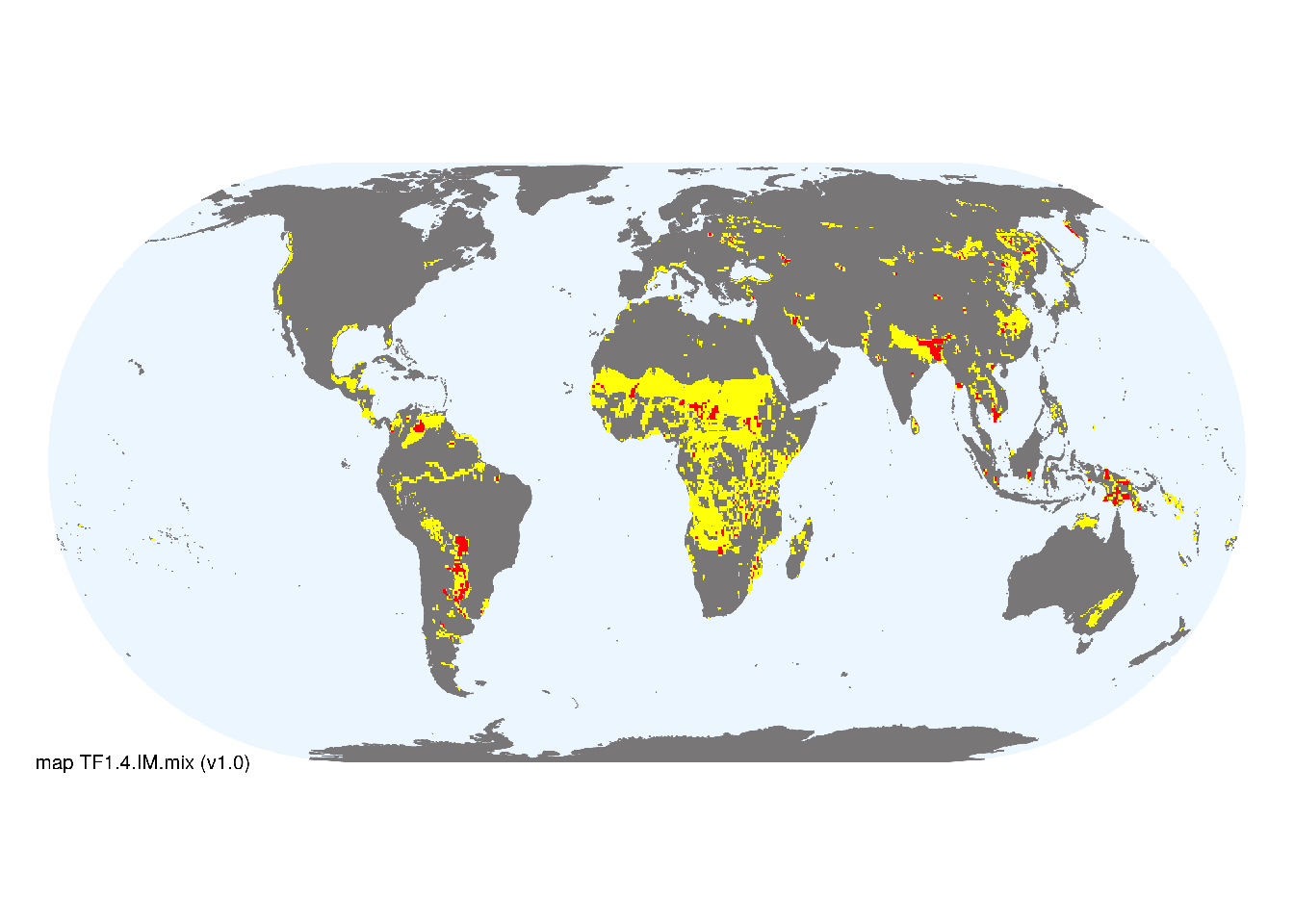
Map description
Major occurrences of freshwater marshes and floodplains were taken from the Global Lakes and Wetlands Database (Lehner and Döll 2004). Occurrences in boreal and polar climates were excluded by removing KoeppnGeiger_classes>26 in Beck et al. (2018). Additional areas with minor occurrences identified in selected freshwater ecoregions (Abell et al. 2008). Ecoregions were selected if: i) their descriptions mentioned features consistent with those identifed in the profile of the Ecosystem Functional Group; and ii) if their location was consistent with the ecological drivers described in the profile..
Map code and version: TF1.4.web.map v1.0, available at ![]()
Version history
Profile versions
- v2.1 (2022-04-06): DA Keith; RT Kingsford; R Mac Nally; B Robson; JA Catford; MC Rains; K Irvine; KM Rodriguez-Clark; A Etter.1
- v2.01 (2021-12-31): NA.
- v2.0 (2020-06-17): DA Keith; RT Kingsford; R Mac Nally; B Robson; JA Catford; MC Rains; K Irvine; KM Rodriguez-Clark; A Etter.
- v1.0 (2020-01-20): DA Keith; RT Kingsford; RC Mac Nally; KM Rodriguez-Clark; A Etter.
Available maps
Read more details about the current map versions here.
- Indicative Map (code: TF1.4.IM.mix, version v1.0)
- Web navigation (code: TF1.4.web.map, version v1.0)

Read more details about older or alternative versions of maps for this functional group.
- Indicative Map: discarded (code: TF1.4.IM.alt, version v2.0)
- Indicative Map: discarded (code: TF1.4.IM.orig, version v1.0)
- Web navigation: requires review (code: TF1.4.web.orig, version v1.0)
- Web navigation: requires review (code: TF1.4.web.mix, version v1.0)
- Web navigation: in preparation (code: TF1.4.WM.nwx, version v1.0)
References
Main references
References used in the different versions of the profiles.
- Damasceno-Junior GA., Semir J, Dos Santos FAM, de Freitas Leitão-Filho H (2005) Structure, distribution of species and inundation in a riparian forest of Rio Paraguai, Pantanal, Brazil Flora-Morphology, Distribution, Functional Ecology of Plants 200:119-135
Map references
References used in the different versions of the maps (current and discarded).
- Abell R, Thieme ML, Revenga C, Bryer M, Kottelat M, Bogutskaya N, Coad B, Mandrak N, Contreras Balderas S, Bussing W, Stiassny MLJ, Skelton P, Allen GR, Unmack P, Naseka A, Ng R, Sindorf N, Robertson J, Armijo E, Higgins JV, Heibel TJ, Wikramanayake E, Olson D, López HL, Reis RE, Lundberg JG, Sabaj Pérez MH, Petry P (2008) Freshwater ecoregions of the world: A new map of biogeographic units for freshwater biodiversity conservation, BioScience 58: 403–414. DOI:10.1641/B580507
- Beck, H., Zimmermann, N., McVicar, T. et al. (2018) Present and future Köppen-Geiger climate classification maps at 1-km resolution Sci Data 5, 180214 DOI:10.1038/sdata.2018.214
- Thomas Gumbricht Rosa Maria Roman‐Cuesta Louis Verchot Martin Herold Florian Wittmann Ethan Householder Nadine Herold Daniel Murdiyarso (2017) An expert system model for mapping tropical wetlands and peatlands reveals South America as the largest contributor Glob Change Biol. 23: 3581– 3599 DOI:10.1111/gcb.13689
- Lehner, B. and Döll, P. (2004): Development and validation of a global database of lakes, reservoirs and wetlands. Journal of Hydrology 296/1-4: 1-22. Data-set
Footnotes
This is the current version available at official site.↩︎