TF1.1 Tropical flooded forests and peat forests
TF1. Palustrine wetlands biome
TF1
Profile summary
Full profile at https://global-ecosystems.org/explore/groups/TF1.1
Brief description
These tropical swamps have closed forest canopies and experience high rainfall and consistent temperatures all year. In some, peat accumulates in anaerobic black water conditions, while others are highly productive white-water systems, with frequent refilling and turnover of nutrients. Trees and other plants, such as palms, pitcher plants, epiphytic mosses and ferns grow in soils that are waterlogged or periodically inundated.
Key features
Evergreen closed-canopy forests in tropical swamps and riparian zones, differing between high and low nutrients waters, and supporting complex trophic networks.
Overview of distribution
Equatorial lowlands of Southeast Asia, South America and Central and West Africa.
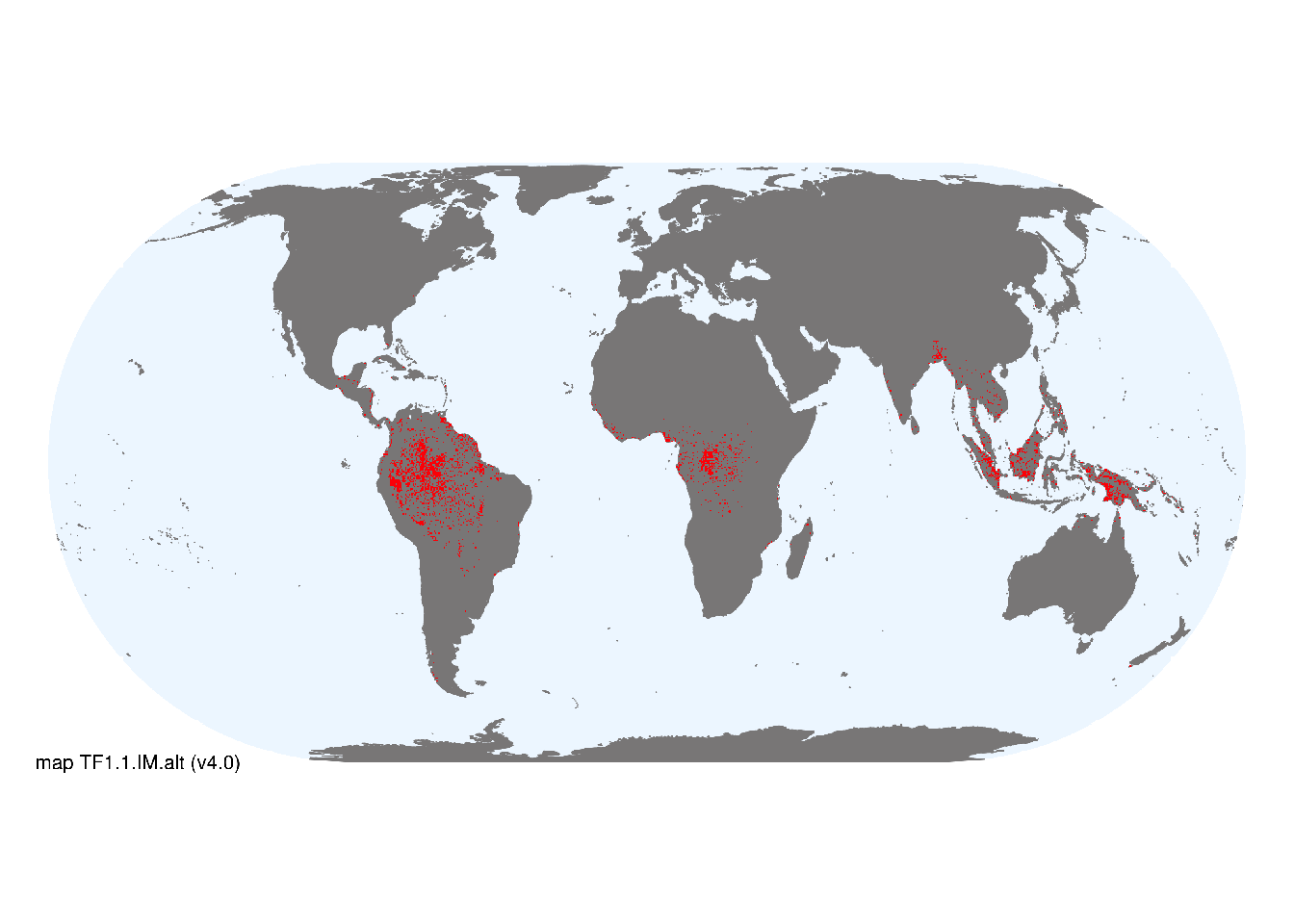
Map description
Major occurrences of swamp and flooded forest were taken from the Global Lakes and Wetlands Database (Lehner and Döll 2004). Additional areas with minor occurrences identified in selected terrestrial ecoregions (Dinerstein et al. 2017). Ecoregions were selected if: i) their descriptions mentioned features consistent with those identified in the profile of the Ecosystem Functional Group; and ii) if their location was consistent with the ecological drivers described in the profile. .
Map code and version: TF1.1.web.map v1.0, available at ![]()
Version history
Profile versions
- v2.1 (2022-04-06): DA Keith; RT Kingsford; R Mac Nally; KM Rodriguez-Clark; A Etter.1
- v2.01 (2021-12-31): NA.
- v2.0 (2020-05-31): DA Keith; RT Kingsford; R Mac Nally; KM Rodriguez-Clark; A Etter.
- v1.0 (2020-01-20): DA Keith; RT Kingsford; RC Mac Nally; KM Rodriguez-Clark; A Etter.
Available maps
Read more details about the current map versions here.
- Indicative Map (code: TF1.1.IM.alt, version v4.0)
- Web navigation (code: TF1.1.web.map, version v1.0)

Read more details about older or alternative versions of maps for this functional group.
- Indicative Map: requires more work (code: TF1.1.IM.alt, version v3.0)
- Indicative Map: discarded (code: TF1.1.IM.alt, version v2.1)
- Indicative Map: discarded (code: TF1.1.IM.alt, version v2.0)
- Web navigation: requires review (code: TF1.1.web.mix, version v2.0)
- Indicative Map: discarded (code: TF1.1.IM.mix, version v2.0)
- Web navigation: in preparation (code: TF1.1.WM.nwx, version v1.0)
- Web navigation: requires review (code: TF1.1.web.orig, version v1.0)
- Indicative Map: discarded (code: TF1.1.IM.mix, version v1.0)
- Indicative Map: discarded (code: TF1.1.IM.orig, version v1.0)
References
Main references
References used in the different versions of the profiles.
- Page SE, Rieley JO, Wüst R (2014) Lowland tropical peatlands of Southeast Asia Peatlands: Evolution and records of environmental and climate changes (Eds. IP Martini, Martínez A Cortizas, W Chesworth), pp145-172. Elsevier, Amsterdam
Map references
References used in the different versions of the maps (current and discarded).
- Lehner, B. and Döll, P. (2004): Development and validation of a global database of lakes, reservoirs and wetlands. Journal of Hydrology 296/1-4: 1-22. Data-set
- Dinerstein E, Olson D, Joshi A, Vynne C, Burgess ND, Wikramanayake E, Hahn N, Palminteri S, Hedao P, Noss R, Hansen M, Locke H, Ellis EE, Jones B, Barber CV, Hayes R, Kormos C, Martin V, Crist E, Sechrest W, Price L, Baillie JEM, Weeden D, Suckling K, Davis C, Sizer N, Moore R, Thau D, Birch T, Potapov P, Turubanova S, Tyukavina A, de Souza N, Pintea L, Brito JC, Llewellyn Barnekow Lillesø JP, van Breugel P, Graudal L, Voge M, Al-Shammari KF, Saleem M (2017) An Ecoregion-Based Approach to Protecting Half the Terrestrial Realm, BioScience 67: 534–545. DOI:10.1093/biosci/bix014. Data-set available on-line
- Martin Jung, Prabhat Raj Dahal, Stuart H. M. Butchart, Paul F. Donald, Xavier De Lamo, Myroslava Lesiv, … Piero Visconti. (2020). A global map of terrestrial habitat types [Data set]. Zenodo. DOI: 10.5281/zenodo.3673586
- Tuanmu, M.-N. and W. Jetz (2014) A global 1-km consensus land-cover product for biodiversity and ecosystem modeling Global Ecology and Biogeography 23(9):1031–1045 DOI:10.1111/geb.12182
- Thomas Gumbricht Rosa Maria Roman‐Cuesta Louis Verchot Martin Herold Florian Wittmann Ethan Householder Nadine Herold Daniel Murdiyarso (2017) An expert system model for mapping tropical wetlands and peatlands reveals South America as the largest contributor Glob Change Biol. 23: 3581– 3599 DOI:10.1111/gcb.13689
Footnotes
This is the current version available at official site.↩︎