T7.3 Plantations
T7. Intensive land-use biome
T7
Profile summary
Full profile at https://global-ecosystems.org/explore/groups/T7.3
Brief description
Plantations are generally long-rotation perennial woody crops established and maintained for a variety of food and materials. The harvested products include wood, various fruits, tea, coffee, palm oil and other food additives, materials such as rubber, ornamental materials (cut flowers), etc. The vegetation of most plantations comprises at least two vertical strata (the managed woody species and a ruderal ground layer), although mixed plantings may be more complex and host a relatively diverse flora and fauna if managed to promote habitat features. Fertilisers and water subsidies are applied, and harvesting occurs at intervals depending on the crop.
Key features
Structurally simple, low-diversity forests of one (rarely, a few) planted tree species of mostly same age, lack of structural elements of old-growth forests such as deadwood or cavities.
Overview of distribution
Abundant in humid or sub-humid, boreal to tropical climates worldwide.
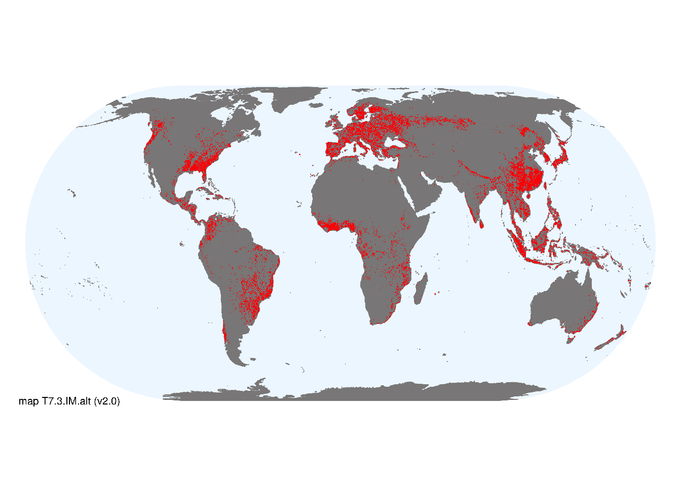
Map description
Major occurrences of plantations were taken from the map of Habitat type 14.3 by Jung et al. (2020) based on the IUCN Habitats Classification Scheme v3.1 (IUCN 2012). We compared this to cropping areas in consensus land-cover maps (Tuanmu et al., 2014) and found that maps of Jung et al. (2020) more closely matched the concept of T7.3..
Map code and version: T7.3.web.alt v2.0, available at ![]()
Version history
Profile versions
- v2.1 (2022-04-06): DA Keith; KR Young.1
- v2.01 (2021-12-31): NA.
- v2.0 (2020-05-31): DA Keith; KR Young.
- v1.0 (2020-01-20): DA Keith.
Available maps
Read more details about the current map versions here.
- Web navigation (code: T7.3.web.alt, version v2.0)

- Indicative Map (code: T7.3.IM.alt, version v2.0)
Read more details about older or alternative versions of maps for this functional group.
- Indicative Map: discarded (code: T7.3.IM.orig, version v1.0)
- Indicative Map: discarded (code: T7.3.IM.mix, version v1.0)
- Web navigation: discarded (code: T7.3.web.mix, version v1.0)
- Web navigation: requires review (code: T7.3.web.orig, version v1.0)
References
Main references
References used in the different versions of the profiles.
- Kanninen M (2010) Plantation forests: global perspectives Ecosystem goods and services from plantation forests (Eds. J Bauhus, PJ van der Meer, M Kanninen), pp1-15. Earthscan, London
- Monfreda CN, Ramankutty N, Foley JA (2008) Farming the planet: 2. Geographic distribution of crop areas, yields, physiological types, and net primary production in the year 2000 Global Biogeochemical Cycles 22: GB1022
Map references
References used in the different versions of the maps (current and discarded).
- Dinerstein E, Olson D, Joshi A, Vynne C, Burgess ND, Wikramanayake E, Hahn N, Palminteri S, Hedao P, Noss R, Hansen M, Locke H, Ellis EE, Jones B, Barber CV, Hayes R, Kormos C, Martin V, Crist E, Sechrest W, Price L, Baillie JEM, Weeden D, Suckling K, Davis C, Sizer N, Moore R, Thau D, Birch T, Potapov P, Turubanova S, Tyukavina A, de Souza N, Pintea L, Brito JC, Llewellyn Barnekow Lillesø JP, van Breugel P, Graudal L, Voge M, Al-Shammari KF, Saleem M (2017) An Ecoregion-Based Approach to Protecting Half the Terrestrial Realm, BioScience 67: 534–545. DOI:10.1093/biosci/bix014. Data-set available on-line
- Martin Jung, Prabhat Raj Dahal, Stuart H. M. Butchart, Paul F. Donald, Xavier De Lamo, Myroslava Lesiv, … Piero Visconti. (2020). A global map of terrestrial habitat types [Data set]. Zenodo. DOI: 10.5281/zenodo.3673586
- Tuanmu, M.-N. and W. Jetz (2014) A global 1-km consensus land-cover product for biodiversity and ecosystem modeling Global Ecology and Biogeography 23(9):1031–1045 DOI:10.1111/geb.12182
Footnotes
This is the current version available at official site.↩︎