T7.2 Sown pastures and fields
T7. Intensive land-use biome
T7
Profile summary
Full profile at https://global-ecosystems.org/explore/groups/T7.2
Brief description
In these intensively managed agricultural systems, grasses and legumes are sown and cultivated, with regular inputs of nutrients and (sometimes) water, primary for the mostly commercial production of livestock or food (hay) for livestock. Sown pastures are structurally simple ecosystems with low-diversity and high-productivity. They are dominated by one or few selected plant species as primary food sources for one animal species (usually large mammalian herbivores). Management includes chemical or physical treatments to exclude competitors, predators, herbivores, or pathogens. They differ from less intensively managed rangeland (e.g. biome T5) and semi-natural grasslands (T7.5), where livestock graze in predominantly native ecosystems.
Key features
Structurally simple, very low- diversity, high-productivity grasslands dominated by one or few species of perennial grasses (Poacaeae) maintained by intensive addition of nutrients, water and artificial disturbance regimes (mowing or grazing).
Overview of distribution
Abundant in humid or sub-humid, boreal to tropical climates worldwide.
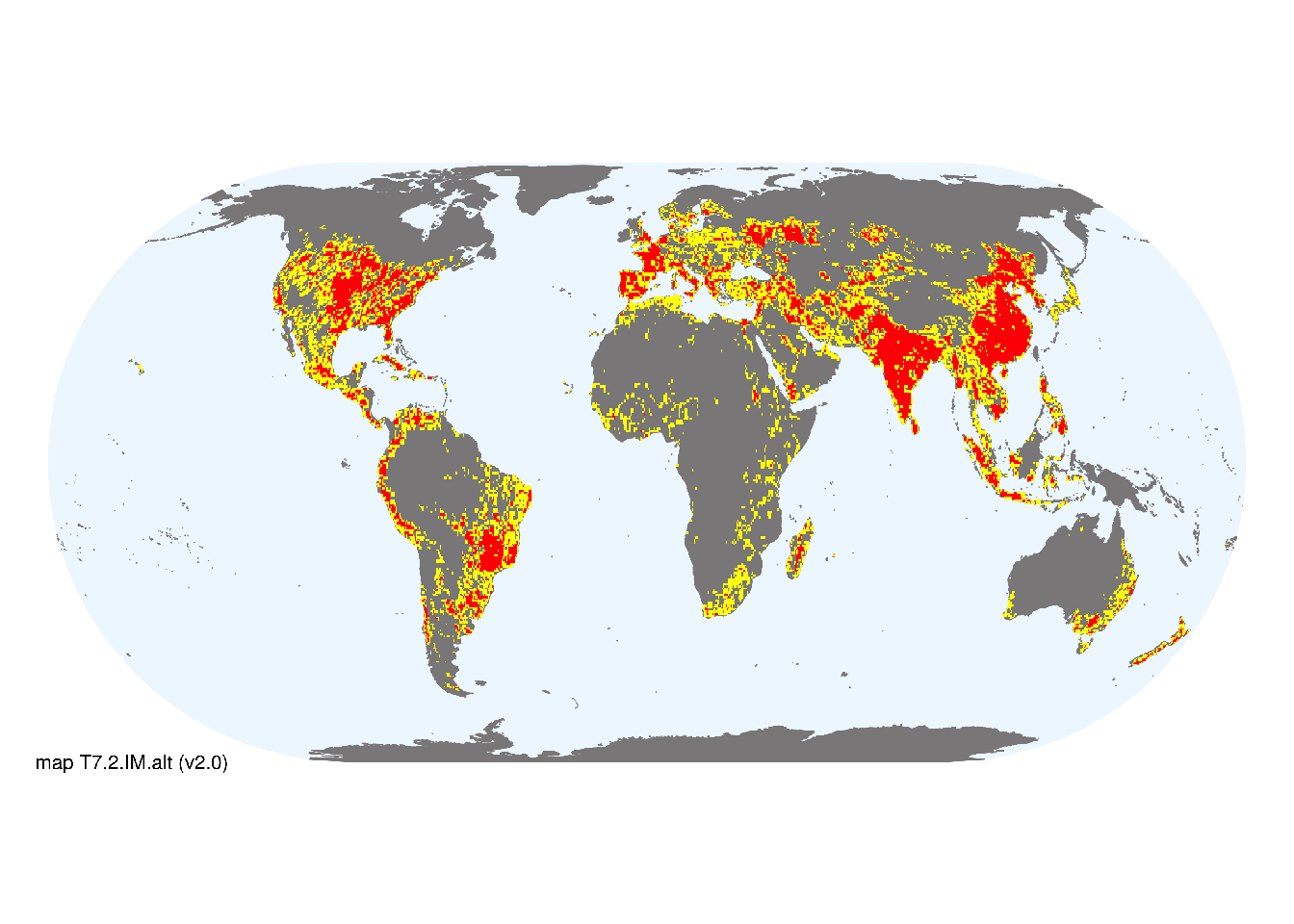
Map description
The presence of sown pastures was approximated by selecting areas of overlap between existing irrigation infrastructure (Siebert et al. 2005; 2013) and presence of major livestock (Gilbert et al. 2018)..
Map code and version: T7.2.web.map v1.0, available at ![]()
Version history
Profile versions
- v2.1 (2022-04-06): DA Keith; R Harper.1
- v2.01 (2021-12-31): NA.
- v2.0 (2020-05-31): DA Keith; R Harper.
- v1.0 (2020-01-20): DA Keith.
Available maps
Read more details about the current map versions here.
- Indicative Map (code: T7.2.WM.nwx, version v1.0)
Read more details about older or alternative versions of maps for this functional group.
- Indicative Map: requires review (code: T7.2.IM.alt, version v2.0)
- Web navigation: invalid (code: T7.2.web.alt, version v2.0)
- Indicative Map: discarded (code: T7.2.IM.mix, version v1.0)
- Web navigation: requires review (code: T7.2.web.mix, version v1.0)
- Web navigation: requires review (code: T7.2.web.orig, version v1.0)
- Indicative Map: discarded (code: T7.2.IM.orig, version v1.0)
- Web navigation: discarded (code: T7.2.web.map, version v1.0)

References
Main references
References used in the different versions of the profiles.
- Bernués A, Ruiz R, Olaizola A, Villalba D, Casasús I (2011) Sustainability of pasture-based livestock farming systems in the European Mediterranean context: Synergies and trade-offs Livestock Science 139: 44–57
- Spedding CRW (1986) Animal production from grass: A systems approach Bioindustrial ecosystems (Eds. DAJ Cole, GC Brander), pp 107-120. Ecosystems of the world vol. 21. Elsevier, Amsterdam
Map references
References used in the different versions of the maps (current and discarded).
- Dinerstein E, Olson D, Joshi A, Vynne C, Burgess ND, Wikramanayake E, Hahn N, Palminteri S, Hedao P, Noss R, Hansen M, Locke H, Ellis EE, Jones B, Barber CV, Hayes R, Kormos C, Martin V, Crist E, Sechrest W, Price L, Baillie JEM, Weeden D, Suckling K, Davis C, Sizer N, Moore R, Thau D, Birch T, Potapov P, Turubanova S, Tyukavina A, de Souza N, Pintea L, Brito JC, Llewellyn Barnekow Lillesø JP, van Breugel P, Graudal L, Voge M, Al-Shammari KF, Saleem M (2017) An Ecoregion-Based Approach to Protecting Half the Terrestrial Realm, BioScience 67: 534–545. DOI:10.1093/biosci/bix014. Data-set available on-line
- Gilbert, M., Nicolas, G., Cinardi, G. et al. Global distribution data for cattle, buffaloes, horses, sheep, goats, pigs, chickens and ducks in 2010. Sci Data 5, 180227 (2018). DOI: 10.1038/sdata.2018.227
- Gilbert M, G Nicolas, G Cinardi, S Vanwambeke, TP Van Boeckel, GRW Wint, TP Robinson (2018) Global Distribution Data for Cattle, Buffaloes, Horses, Sheep, Goats, Pigs, Chickens and Ducks in 2010 Nature Scientific data 5:180227 DOI:10.1038/sdata.2018.227
- Helmut Haberl, K. Heinz Erb, Fridolin Krausmann, Veronika Gaube, Alberte Bondeau, Christoph Plutzar, Simone Gingrich, Wolfgang Lucht, Marina Fischer-Kowalski (2007) Quantifying and mapping the human appropriation of net primary production in earth’s terrestrial ecosystems Proceedings of the National Academy of Sciences 104 (31) 12942-12947 DOI:10.1073/pnas.0704243104
- Ramankutty, N., A.T. Evan, C. Monfreda, and J.A. Foley (2008) Farming the planet: 1. Geographic distribution of global agricultural lands in the year 2000 Global Biogeochemical Cycles 22, GB1003 DOI:10.1029/2007GB002952
- Siebert, S., Döll, P., Hoogeveen, J., Faures, J.-M., Frenken, K., Feick, S. (2005) Development and validation of the global map of irrigation areas Hydrology and Earth System Sciences 9, 535-547
- Siebert, S., Henrich, V., Frenken, K., Burke, J. (2013): Update of the Global Map of Irrigation Areas to version 5. Project report, 178 p.
- Tuanmu, M.-N. and W. Jetz (2014) A global 1-km consensus land-cover product for biodiversity and ecosystem modeling Global Ecology and Biogeography 23(9):1031–1045 DOI:10.1111/geb.12182
Footnotes
This is the current version available at official site.↩︎