T7.1 Annual croplands
T7. Intensive land-use biome
T7
Profile summary
Full profile at https://global-ecosystems.org/explore/groups/T7.1
Brief description
Croplands are intensively managed agricultural ecosystems maintained by supplementation of nutrients and water, sowing and harvesting, soil cultivation and control of non-target plants and animals (weeds and pests). They currently cover 11% of the world’s land surface. Some systems of management include domestic herbivores introduced on harvested stubble or in ‘fallow’ years. These are structurally simple, very low-diversity, high-productivity systems, dominated by one or few non-woody, shallow-rooted annual plant species such as grains (mostly C3 grasses), vegetables, ‘cut flowers’, legumes, or fibre plants harvested annually by humans for commercial or subsistence production of food, materials, or ornamental displays.
Key features
Structurally simple, very low- diversity, high-productivity annual croplands are maintained by the intensive anthropogenic supplementation of nutrients, water and artificial disturbance regimes.
Overview of distribution
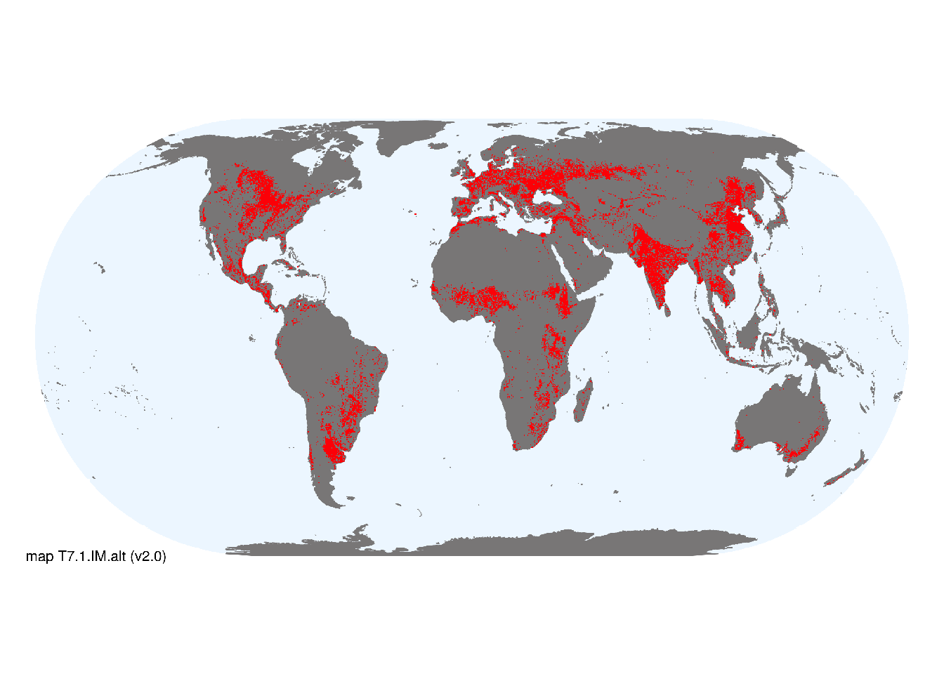
Tropical to temperate humid climatic zones or river flats in dry climates across south sub-Saharan and North Africa, Europe, Asia, southern Australia, Oceania, and the Americas..
Map description
Major occurrences of croplands were taken from the map of Habitat type 14.1 by Jung et al. (2020) based on the IUCN Habitats Classification Scheme v3.1 (IUCN 2012). We compared this to cropping areas in consensus land-cover maps (Tuanmu et al., 2014) and found that maps of Jung et al. (2020) more closely matched the concept of T7.1..
Map code and version: T7.1.web.alt v2.0, available at ![]()
Version history
Profile versions
- v2.1 (2022-04-06): DA Keith; R Harper.1
- v2.01 (2021-12-31): NA.
- v2.0 (2020-05-31): DA Keith; R Harper.
- v1.0 (2020-01-20): DA Keith.
Available maps
Read more details about the current map versions here.
- Web navigation (code: T7.1.web.alt, version v2.0)

- Indicative Map (code: T7.1.IM.alt, version v2.0)
Read more details about older or alternative versions of maps for this functional group.
- Web navigation: requires review (code: T7.1.web.orig, version v1.0)
- Indicative Map: discarded (code: T7.1.IM.orig, version v1.0)
- Web navigation: discarded (code: T7.1.web.mix, version v1.0)
- Web navigation: in preparation (code: T7.1.WM.nwx, version v1.0)
- Indicative Map: discarded (code: T7.1.IM.mix, version v1.0)
References
Main references
References used in the different versions of the profiles.
- Leff B, Ramankutty N, Foley JA (2004) Geographic distribution of major crops across the world Global Biogeochemical Cycles 18(1), GB1009
- Ray DK., Foley JA (2013) Increasing global crop harvest frequency: recent trends and future directions Environmental Research Letters 8(4): 044041 DOI:10.1088/1748-9326/8/4/044041
Map references
References used in the different versions of the maps (current and discarded).
- Dinerstein E, Olson D, Joshi A, Vynne C, Burgess ND, Wikramanayake E, Hahn N, Palminteri S, Hedao P, Noss R, Hansen M, Locke H, Ellis EE, Jones B, Barber CV, Hayes R, Kormos C, Martin V, Crist E, Sechrest W, Price L, Baillie JEM, Weeden D, Suckling K, Davis C, Sizer N, Moore R, Thau D, Birch T, Potapov P, Turubanova S, Tyukavina A, de Souza N, Pintea L, Brito JC, Llewellyn Barnekow Lillesø JP, van Breugel P, Graudal L, Voge M, Al-Shammari KF, Saleem M (2017) An Ecoregion-Based Approach to Protecting Half the Terrestrial Realm, BioScience 67: 534–545. DOI:10.1093/biosci/bix014. Data-set available on-line
- Martin Jung, Prabhat Raj Dahal, Stuart H. M. Butchart, Paul F. Donald, Xavier De Lamo, Myroslava Lesiv, … Piero Visconti. (2020). A global map of terrestrial habitat types [Data set]. Zenodo. DOI: 10.5281/zenodo.3673586
- Klein Goldewijk K, van Drecht G (2006) HYDE 3: current and historical population and land cover. Integrated modelling of global environmental change. An overview of IMAGE 2.4 (Eds AF Bouwman, T Kram K Klein Goldewijk), pp. 93–111. Netherlands Environmental Assessment Agency (MNP). Bilthoven, The Netherlands.
- Ramankutty, N., A.T. Evan, C. Monfreda, and J.A. Foley (2008) Farming the planet: 1. Geographic distribution of global agricultural lands in the year 2000 Global Biogeochemical Cycles 22, GB1003 DOI:10.1029/2007GB002952
- Tuanmu, M.-N. and W. Jetz (2014) A global 1-km consensus land-cover product for biodiversity and ecosystem modeling Global Ecology and Biogeography 23(9):1031–1045 DOI:10.1111/geb.12182
Footnotes
This is the current version available at official site.↩︎