T6.4 Temperate alpine grasslands and shrublands
T6. Polar/alpine (cryogenic) biome
T6
Profile summary
Full profile at https://global-ecosystems.org/explore/groups/T6.4
Brief description
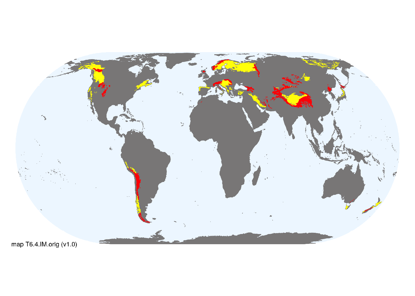
Temperate alpine grasslands and shrublands occur above the treeline, on temperate and boreal mountains worldwide. Seasonal productivity is limited by cold and snow cover, often with strong winds. Mosses, liverworts, lichens, flowering plants and low shrubs generally form a continuous cover, except where strong winds and dry conditions limit vegetation to sparse lichens and dwarf shrubs. Most fauna is seasonally active during warmer summer months, with insects and vertebrates having adaptations to extreme cold, including hibernation. Many species have restricted distributions, with strong barriers to dispersal between mountains.
Key features
Mountain systems above the physiological limits of trees, with sparse to continuous cover of herbaceous plants, cryptogams and dwarf shrubs that may be morphologically adaptated to extreme cold..
Overview of distribution
Ttemperate and boreal zones of the Americas, Europe, central Eurasia, west and north Asia, Australia, and New Zealand.
Map description
Terrestrial ecoregions containing major or minor occurrences of this ecosystem functional group were identified by consulting available ecoregion descriptions (Dinerstein et al. 2017), global and regional reviews, national and regional ecosystem maps, locations of relevant examples, and proofed by expert reviewers. Consequently they are coarse-scale indicative representations of distribution, except where they occupy small ecoregions. Ecoregions were mapped at 30 arc second spatial resolution..
Map code and version: T6.4.web.orig v1.0, available at ![]()
Version history
Profile versions
- v2.1 (2022-04-06): DA Keith; F Essl; KR Young; CH Körner.1
- v2.01 (2021-12-31): NA.
- v2.0 (2020-05-31): DA Keith; F Essl; KR Young; CH Körner.
- v1.0 (2020-01-20): DA Keith; F Essl.
Available maps
Read more details about the current map versions here.
- Indicative Map (code: T6.4.IM.orig, version v1.0)
- Web navigation (code: T6.4.web.orig, version v1.0)

Read more details about older or alternative versions of maps for this functional group.
- Indicative Map: discarded (code: T6.4.IM.mix, version v1.0)
- Web navigation: requires review (code: T6.4.web.mix, version v1.0)
- Web navigation: in preparation (code: T6.4.WM.nwx, version v1.0)
References
Main references
References used in the different versions of the profiles.
- Körner C (2012) Alpine treelines Springer, Basel. ISBN 978-3-0348-0396-0 DOI:978-3-0348-0396-0
- Körner C (2004) Mountain biodiversity: its causes and function Ambio Special Report Number 13. The Royal Colloquium: Mountain Areas: A Global Resource, pp. 11-17. Springer, Berlin DOI:10.4324/9780429342585-1
- Paulsen J, Körner C (2014) A climate-based model to predict potential treeline position around the globe Alpine Botany 124, 1-12 DOI:10.1007/s00035-014-0124-0
Map references
References used in the different versions of the maps (current and discarded).
- Dinerstein E, Olson D, Joshi A, Vynne C, Burgess ND, Wikramanayake E, Hahn N, Palminteri S, Hedao P, Noss R, Hansen M, Locke H, Ellis EE, Jones B, Barber CV, Hayes R, Kormos C, Martin V, Crist E, Sechrest W, Price L, Baillie JEM, Weeden D, Suckling K, Davis C, Sizer N, Moore R, Thau D, Birch T, Potapov P, Turubanova S, Tyukavina A, de Souza N, Pintea L, Brito JC, Llewellyn Barnekow Lillesø JP, van Breugel P, Graudal L, Voge M, Al-Shammari KF, Saleem M (2017) An Ecoregion-Based Approach to Protecting Half the Terrestrial Realm, BioScience 67: 534–545. DOI:10.1093/biosci/bix014. Data-set available on-line
- Testolin, R., Attorre, F. and Jiménez‐Alfaro, B. (2020) Global distribution and bioclimatic characterization of alpine biomes Ecography 43: 779-788 DOI:10.1111/ecog.05012
- Tuanmu, M.-N. and W. Jetz (2014) A global 1-km consensus land-cover product for biodiversity and ecosystem modeling Global Ecology and Biogeography 23(9):1031–1045 DOI:10.1111/geb.12182
Footnotes
This is the current version available at official site.↩︎