T6.3 Polar tundra and deserts
T6. Polar/alpine (cryogenic) biome
T6
Profile summary
Full profile at https://global-ecosystems.org/explore/groups/T6.3
Brief description
Polar tundra and deserts have continuous to sparse cover of cold-tolerant mosses, liverworts, lichens, grasses, low shrubs and other flowering plants. They occur primarily in the Arctic circle, but polar desert is found in dry coastal lowlands of Antarctica. Precipitation falls as snow, with seasonal snow cover limiting the growing season. Extreme cold temperatures and short growing seasons exclude trees, as well as vascular plants in the coldest and driest locations. Permafrost substrates accumulate peat through slow decomposition rates. Migratory birds feed in distant wetlands or open oceans, and contribute nutrients to the system through guano, as well as dispersing seeds and other organisms. Migratory or hibernating mammals include seals, and, in the north, polar bears, foxes and wolves.
Key features
Open and low vegetation of herbaceous plants (e.g. tussocks, cushions, rosette plants) and abundant kryptogams in very cold climates with permafrost.
Overview of distribution
Locally in northern Europe (Scandinavia, Russia), northern Siberia and North America.
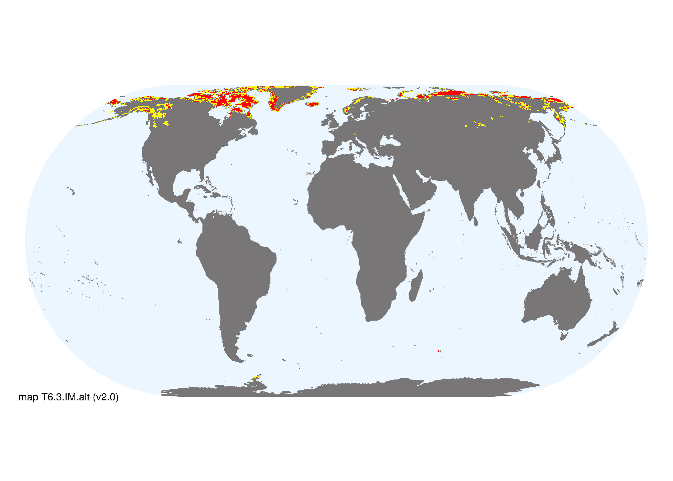
Map description
Areas corresponding to the tundra climatic zone according to the Köppen-Geiger classification system (Beck et al. 2018) were first identified. Additional areas were then selected in high latitudes corresponding with low annual solar radiation (values <1800 in Beckmann et al. 2014). A union of these maps was created at 30 arc seconds spatial resolution in geographic projection..
Map code and version: T6.3.web.map v1.0, available at ![]()
Version history
Profile versions
- v2.1 (2022-04-06): DA Keith; F Essl; KR Young; CH Körner.1
- v2.01 (2021-12-31): NA.
- v2.0 (2020-05-31): DA Keith; F Essl; KR Young; CH Körner.
- v1.0 (2020-01-20): DA Keith; D Faber-Langendoen.
Available maps
Read more details about the current map versions here.
- Indicative Map (code: T6.3.IM.alt, version v2.0)
- Web navigation (code: T6.3.web.map, version v1.0)

Read more details about older or alternative versions of maps for this functional group.
- Indicative Map: discarded (code: T6.3.IM.alt, version v2.1)
- Web navigation: replaced (code: T6.3.web.alt, version v2.0)
- Web navigation: requires review (code: T6.3.web.orig, version v1.0)
- Web navigation: requires review (code: T6.3.web.mix, version v1.0)
- Indicative Map: discarded (code: T6.3.IM.mix, version v1.0)
- Indicative Map: discarded (code: T6.3.IM.orig, version v1.0)
References
Main references
References used in the different versions of the profiles.
- Crawford RMM (2013) Tundra-taiga biology. Ch 5. Oxford University Press, Oxford.
- Paulsen J, Körner C (2014) A climate-based model to predict potential treeline position around the globe Alpine Botany 124, 1-12 DOI:10.1007/s00035-014-0124-0
Map references
References used in the different versions of the maps (current and discarded).
- Beck, H., Zimmermann, N., McVicar, T. et al. (2018) Present and future Köppen-Geiger climate classification maps at 1-km resolution Sci Data 5, 180214 DOI:10.1038/sdata.2018.214
- Beckmann M., Václavík T., Manceur A.M., Šprtová L., von Wehrden H., Welk E., Cord A.F. (2014) glUV: A global UV-B radiation dataset for macroecological studies Methods in Ecology and Evolution 5: 372–383. DOI:10.1111/2041-210X.12168
- Dinerstein E, Olson D, Joshi A, Vynne C, Burgess ND, Wikramanayake E, Hahn N, Palminteri S, Hedao P, Noss R, Hansen M, Locke H, Ellis EE, Jones B, Barber CV, Hayes R, Kormos C, Martin V, Crist E, Sechrest W, Price L, Baillie JEM, Weeden D, Suckling K, Davis C, Sizer N, Moore R, Thau D, Birch T, Potapov P, Turubanova S, Tyukavina A, de Souza N, Pintea L, Brito JC, Llewellyn Barnekow Lillesø JP, van Breugel P, Graudal L, Voge M, Al-Shammari KF, Saleem M (2017) An Ecoregion-Based Approach to Protecting Half the Terrestrial Realm, BioScience 67: 534–545. DOI:10.1093/biosci/bix014. Data-set available on-line
- Martin Jung, Prabhat Raj Dahal, Stuart H. M. Butchart, Paul F. Donald, Xavier De Lamo, Myroslava Lesiv, … Piero Visconti. (2020). A global map of terrestrial habitat types [Data set]. Zenodo. DOI: 10.5281/zenodo.3673586
- Tuanmu, M.-N. and W. Jetz (2014) A global 1-km consensus land-cover product for biodiversity and ecosystem modeling Global Ecology and Biogeography 23(9):1031–1045 DOI:10.1111/geb.12182
Footnotes
This is the current version available at official site.↩︎