T6.2 Polar/alpine cliffs, screes, outcrops and lava flows
T6. Polar/alpine (cryogenic) biome
T6
Profile summary
Full profile at https://global-ecosystems.org/explore/groups/T6.2
Brief description
Polar-alpine rocky outcrops occur in permanently ice-free areas of polar regions and high mountains. Productivity and biomass are limited by extreme cold, rocky substrate and strong winds. Algae, lichens, mosses and bacteria support a short and simple foodweb in the summer months, with cold-tolerant invertebrates such as tardigrades. Some rocky sites provide nesting sites for birds in summer. Substrate weathering and guano are major nutrient inputs. These systems are periodically disturbed as accumulated snow and ice collapses down steep slopes.
Key features
Environments free of permanent ice where extreme cold, winds, skeletal substrates and periodic mass movement limit biota to cryptogams, invertebrates and microorganisms, nesting birds may occur..
Overview of distribution
Permanently ice-free areas of Antarctica, Greenland, the Arctic Circle, and high mountains in the western Americas, central Asia, Europe, Africa and New Zealand..
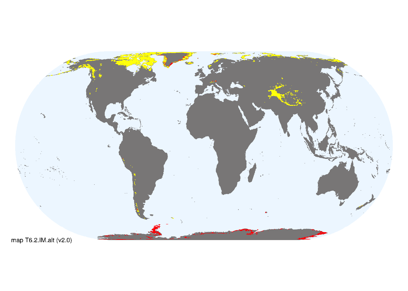
Map description
Known locations of prominent ice-free rock in glacial and alpine environments were selected from global geographical gazeteers (GeoNames 2020), glacier inventories (Raup et al 2007; GLIMS and NSIDC 2005-2018) and the Antarctic Land Cover map for 2000 (Hui et al. 2017). Further areas with mixed occurrence of barren and snow/ice cover were identified from the Circumpolar Arctic Vegetation Map (Raynolds et al. 2019), the USGS EROS LandCover GLCCDB, version 2 (Loveland et al. 2000) and a 1km consensus land-cover map (Tuanmu et al. 2014). A composite map was created at 30 arc seconds spatial resolution in geographic projection, occurrences were then aggregated to half degree cells. Cells containing at least one known location were designated as major occurrences, while those mapped as mixed barren and snow/ice cover were designated as minor occurrences if snow/ice covered at least 2.5% of the cell area..
Map code and version: T6.2.web.alt v2.0, available at ![]()
Version history
Profile versions
- v2.1 (2022-04-06): DA Keith; KR Young; A Terauds.1
- v2.01 (2021-12-31): NA.
- v2.0 (2020-06-15): DA Keith; KR Young; A Terauds.
- v1.0 (2020-01-20): DA Keith; A Terauds.
Available maps
Read more details about the current map versions here.
- Indicative Map (code: T6.2.IM.alt, version v2.0)
- Web navigation (code: T6.2.web.alt, version v2.0)

Read more details about older or alternative versions of maps for this functional group.
- Indicative Map: discarded (code: T6.2.IM.orig, version v1.0)
- Indicative Map: discarded (code: T6.2.IM.mix, version v1.0)
- Web navigation: requires review (code: T6.2.web.orig, version v1.0)
References
Main references
References used in the different versions of the profiles.
- Chown SL, Clarke A, Fraser CI, Cary SC, Moon KL, McGeoch MA (2015) The changing form of Antarctic Biodiversity Nature 522: 431-438
- Convey P, Stevens PI (2007) Antarctic Biodiversity Science 317: 1877-1878 DOI:10.1126/science.1147261
Map references
References used in the different versions of the maps (current and discarded).
- Dinerstein E, Olson D, Joshi A, Vynne C, Burgess ND, Wikramanayake E, Hahn N, Palminteri S, Hedao P, Noss R, Hansen M, Locke H, Ellis EE, Jones B, Barber CV, Hayes R, Kormos C, Martin V, Crist E, Sechrest W, Price L, Baillie JEM, Weeden D, Suckling K, Davis C, Sizer N, Moore R, Thau D, Birch T, Potapov P, Turubanova S, Tyukavina A, de Souza N, Pintea L, Brito JC, Llewellyn Barnekow Lillesø JP, van Breugel P, Graudal L, Voge M, Al-Shammari KF, Saleem M (2017) An Ecoregion-Based Approach to Protecting Half the Terrestrial Realm, BioScience 67: 534–545. DOI:10.1093/biosci/bix014. Data-set available on-line
- GeoNames (2020) The GeoNames geographical database [https://www.geonames.org] Accessed in Feb 2020
- GLIMS and NSIDC (2005, updated 2018): Global Land Ice Measurements from Space glacier database. Compiled and made available by the international GLIMS community and the National Snow and Ice Data Center, Boulder CO, U.S.A. DOI:10.7265/N5V98602
- Hui, F., J. Kang, Y. Liu, X. Cheng, P. Gong, F. Wang, Z. Li, Y. Ye, and Z. Guo. 2017. AntarcticaLC2000: The new Antarctic land cover database for the year 2000. SCIENCE CHINA Earth Sciences 60: 686-696. doi: 10.1007/s11430-016-0029-2.
- Loveland, T.R., Reed, B.C., Brown, J.F., Ohlen, D.O., Zhu, J, Yang, L., and Merchant, J.W. (2000) Development of a Global Land Cover Characteristics Database and IGBP DISCover from 1-km AVHRR Data International Journal of Remote Sensing v. 21, no. 6/7, p. 1303-1330 DOI:10.1080/014311600210191
- Raup, B.H.; A. Racoviteanu; S.J.S. Khalsa; C. Helm; R. Armstrong; Y. Arnaud (2007) The GLIMS Geospatial Glacier Database: a New Tool for Studying Glacier Change Global and Planetary Change 56:101–110 DOI:10.1016/j.gloplacha.2006.07.018
- Martha K. Raynolds, Donald A. Walker, Andrew Balser, Christian Bay, Mitch Campbell, Mikhail M. Cherosov, Fred J.A. Daniëls, Pernille Bronken Eidesen, Ksenia A. Ermokhina, Gerald V. Frost, Birgit Jedrzejek, M. Torre Jorgenson, Blair E. Kennedy, Sergei S. Kholod, Igor A. Lavrinenko, Olga V. Lavrinenko, Borgþór Magnússon, Nadezhda V. Matveyeva, Sigmar Metúsalemsson, Lennart Nilsen, Ian Olthof, Igor N. Pospelov, Elena B. Pospelova, Darren Pouliot, Vladimir Razzhivin, Gabriela Schaepman-Strub, Jozef Šibík, Mikhail Yu. Telyatnikov, Elena Troeva (2019) A raster version of the Circumpolar Arctic Vegetation Map (CAVM) Remote Sensing of Environment 232: 111297, https://doi.org/10.1016/j.rse.2019.111297.
- Tuanmu, M.-N. and W. Jetz (2014) A global 1-km consensus land-cover product for biodiversity and ecosystem modeling Global Ecology and Biogeography 23(9):1031–1045 DOI:10.1111/geb.12182
Footnotes
This is the current version available at official site.↩︎