T5.5 Hyper-arid deserts
T5. Deserts and semi-deserts biome
T5
Profile summary
Full profile at https://global-ecosystems.org/explore/groups/T5.5
Brief description
The most extreme of all desert ecosystems, hyper-arid deserts are limited by very dry and often windy conditions with high temperatures and sandy or stony soils. Dry periods may be prolonged for several years. Vegetation is characterised by very low densities of small drought-tolerant perennial plants known as xerophytes, very slow growing species with adaptations to drought such as extensive root systems and water storage tissues. Some of these plants may acquire much of their moisture from fogs. Ephemeral plants occur in some regions, but are less common than in other desert systems. Microbial biofilms are important decomposers. Drought tolerant reptiles and invertebrates are the main faunal groups, along with occasional nomadic mammals and birds, in simple foodwebs.
Key features
Very sparsely vegetated ecosystems in areas with very low or no precipitation; very low productivity and simple trophic structures; low diversitybut high endemism.
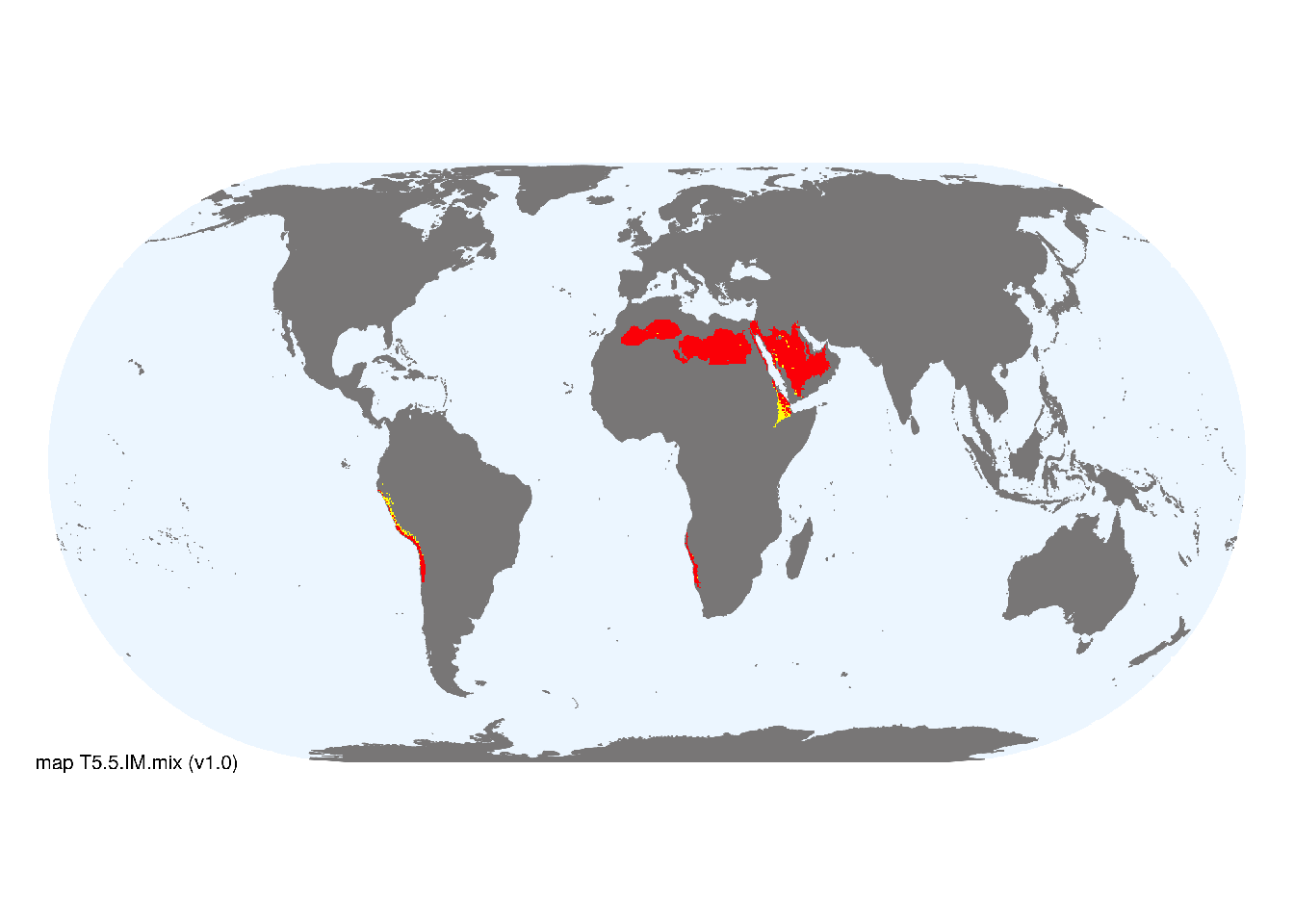
Overview of distribution
Driest parts of the Sahara-Arabian, Atacama, and Namib deserts in subtropical latitudes.
Map description
Major and minor occurrences were initially identified using consensus land-cover maps (Tuanmu et al. 2014) and then cropped to selected terrestrial ecoregions (Dinerstein et al. 2017) at 30 arc seconds spatial resolution. Ecoregions were selected if: i) their descriptions mentioned features consistent with those identified in the profile of the Ecosystem Functional Group; and ii) if their location was consistent with the ecological drivers described in the profile..
Map code and version: T5.5.web.mix v1.0, available at ![]()
Version history
Profile versions
- v2.1 (2022-04-06): MG Tozer; D Faber-Langendoen; DA Keith.1
- v2.01 (2021-12-31): NA.
- v2.0 (2020-05-31): MG Tozer; D Faber-Langendoen; DA Keith.
- v1.0 (2020-01-20): MG Tozer; D Faber-Langendoen; DA Keith.
Available maps
Read more details about the current map versions here.
- Indicative Map (code: T5.5.IM.mix, version v1.0)
- Web navigation (code: T5.5.web.mix, version v1.0)

Read more details about older or alternative versions of maps for this functional group.
- Indicative Map: replaced (code: T5.5.IM.alt, version v2.0)
- Indicative Map: discarded (code: T5.5.IM.orig, version v1.0)
- Web navigation: requires review (code: T5.5.web.orig, version v1.0)
- Web navigation: in preparation (code: T5.5.WM.nwx, version v1.0)
References
Main references
References used in the different versions of the profiles.
- Rundel P W, Dillon MO, Palma B, Mooney HA, Gulmon SL, Ehleringer JR (1991) The phytogeography and ecology of the coastal Atacama and Peruvian deserts Aliso 13(1): 2 DOI:10.5642/aliso.19911301.02
- Zablocki O, Adriaenssens EM, Cowan D (2016) Diversity and ecology of viruses in hyperarid desert soils Applied and Environmental Microbioly 82: 770 –777 DOI:10.1128/aem.02651-15
Map references
References used in the different versions of the maps (current and discarded).
- Abatzoglou, J.T., S.Z. Dobrowski, S.A. Parks, K.C. Hegewisch (2018) Terraclimate, a high-resolution global dataset of monthly climate and climatic water balance from 1958-2015 Scientific Data 5, 170191 DOI:10.1038/sdata.2017.191
- Cherlet, M., Hutchinson, C., Reynolds, J., Hill, J., Sommer, S., von Maltitz, G. (2018) World Atlas of Desertification Publication Office of the European Union, Luxembourg.
- Dinerstein E, Olson D, Joshi A, Vynne C, Burgess ND, Wikramanayake E, Hahn N, Palminteri S, Hedao P, Noss R, Hansen M, Locke H, Ellis EE, Jones B, Barber CV, Hayes R, Kormos C, Martin V, Crist E, Sechrest W, Price L, Baillie JEM, Weeden D, Suckling K, Davis C, Sizer N, Moore R, Thau D, Birch T, Potapov P, Turubanova S, Tyukavina A, de Souza N, Pintea L, Brito JC, Llewellyn Barnekow Lillesø JP, van Breugel P, Graudal L, Voge M, Al-Shammari KF, Saleem M (2017) An Ecoregion-Based Approach to Protecting Half the Terrestrial Realm, BioScience 67: 534–545. DOI:10.1093/biosci/bix014. Data-set available on-line
- Harris, I., Jones, P.D., Osborn, T.J. and Lister, D.H. (2014), Updated high-resolution grids of monthly climatic observations - the CRU TS3.10 Dataset. International Journal of Climatology 34, 623-642 doi:10.1002/joc.3711 Revised appendix
- Trabucco, Antonio; Zomer, Robert (2019) Global Aridity Index and Potential Evapotranspiration (ET0) Climate Database v2 figshare Fileset DOI:10.6084/m9.figshare.7504448.v3
- Tuanmu, M.-N. and W. Jetz (2014) A global 1-km consensus land-cover product for biodiversity and ecosystem modeling Global Ecology and Biogeography 23(9):1031–1045 DOI:10.1111/geb.12182
- UNEP (1992) World atlas of desertification, edited by N. Middleton and D. S. G. Thomas. Edward Arnold (United Nations Environment Programme), London. ISBN 0 340 55512 2
Footnotes
This is the current version available at official site.↩︎