T4.5 Temperate subhumid grasslands
T4. Savannas and grasslands biome
T4
Profile summary
Full profile at https://global-ecosystems.org/explore/groups/T4.5
Brief description
Temperate subhumid grasslands are simple in structure, composed of tussock grasses with scattered forbs, with few isolated trees and shrubs. Cold winters with occasional to frequent snow and frost limit the growing season, but hot dry summers create water stress. Nonetheless, fertile soils enable high productivity after rains, supporting a complex foodweb of invertebrates, ground-nesting birds, burrowing mammals, large herbivores, reptiles and predators. Large herbivores graze heavily, range widely, and are important in maintaining coexistence of plant species and nutrient cycling, as are periodic fires.
Key features
Tussock grasslands with mixtures of C3 and C4 grasses and interstitial forbs, high productivity and complex trophic networks.
Overview of distribution
Temperate regions worldwide with summer water deficit, aseasonal precipitation that along with temperatures are lower than T4.4.
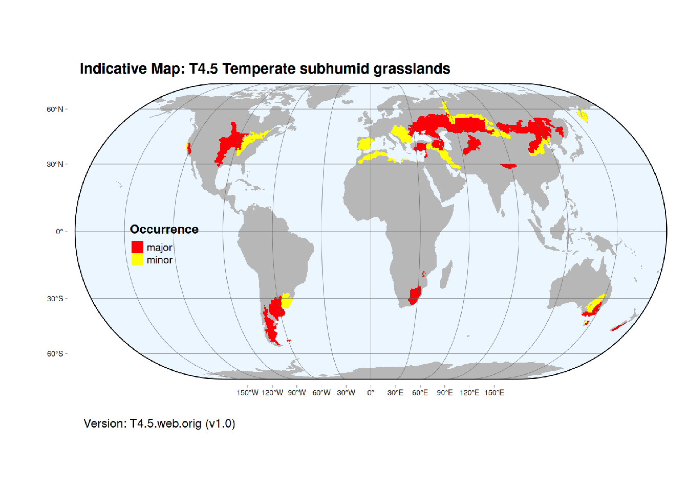
Map description
Terrestrial ecoregions containing major or minor occurrences of this ecosystem functional group were identified by consulting available ecoregion descriptions (Dinerstein et al. 2017), global and regional reviews, national and regional ecosystem maps, locations of relevant examples, and proofed by expert reviewers. Consequently they are coarse-scale indicative representations of distribution, except where they occupy small ecoregions. Ecoregions were mapped at 30 arc second spatial resolution..
Map code and version: T4.5.web.orig v1.0, available at ![]()
Version history
Profile versions
- v2.1 (2022-04-06): DA Keith; F Essl; DJ Gibson.1
- v2.01 (2021-12-31): NA.
- v2.0 (2020-05-31): DA Keith; F Essl; DJ Gibson.
- v1.0 (2020-01-20): DA Keith; F Essl.
Available maps
Read more details about the current map versions here.
- Indicative Map (code: T4.5.IM.orig, version v1.0)
- Web navigation (code: T4.5.web.orig, version v1.0)

Read more details about older or alternative versions of maps for this functional group.
- Indicative Map: discarded (code: T4.5.IM.alt, version v2.1)
- Indicative Map: discarded (code: T4.5.IM.mix, version v1.0)
References
Main references
References used in the different versions of the profiles.
- Gibson GJ (2009) Grasses and grassland ecology Oxford University Press, Oxford
Map references
References used in the different versions of the maps (current and discarded).
- Dinerstein E, Olson D, Joshi A, Vynne C, Burgess ND, Wikramanayake E, Hahn N, Palminteri S, Hedao P, Noss R, Hansen M, Locke H, Ellis EE, Jones B, Barber CV, Hayes R, Kormos C, Martin V, Crist E, Sechrest W, Price L, Baillie JEM, Weeden D, Suckling K, Davis C, Sizer N, Moore R, Thau D, Birch T, Potapov P, Turubanova S, Tyukavina A, de Souza N, Pintea L, Brito JC, Llewellyn Barnekow Lillesø JP, van Breugel P, Graudal L, Voge M, Al-Shammari KF, Saleem M (2017) An Ecoregion-Based Approach to Protecting Half the Terrestrial Realm, BioScience 67: 534–545. DOI:10.1093/biosci/bix014. Data-set available on-line
- Martin Jung, Prabhat Raj Dahal, Stuart H. M. Butchart, Paul F. Donald, Xavier De Lamo, Myroslava Lesiv, … Piero Visconti. (2020). A global map of terrestrial habitat types [Data set]. Zenodo. DOI: 10.5281/zenodo.3673586
- Tuanmu, M.-N. and W. Jetz (2014) A global 1-km consensus land-cover product for biodiversity and ecosystem modeling Global Ecology and Biogeography 23(9):1031–1045 DOI:10.1111/geb.12182
Footnotes
This is the current version available at official site.↩︎