T4.4 Temperate woodlands
T4. Savannas and grasslands biome
T4
Profile summary
Full profile at https://global-ecosystems.org/explore/groups/T4.4
Brief description
Temperate woodlands are structurally simple, with widely-spaced trees and a ground layer of grasses with scattered shrubs. They are globally distributed in temperate climates with warm-season droughts. Tree foliage is typically evergreen, but may be deciduous in cold dry climates. During warm summers, productive grasses on fertile soils sustain a complex foodweb of insects, reptiles, birds and mammals. The ground flora varies with rainfall and tree cover, which creates diverse microhabitats beneath. Large herbivores and their predators are important to maintaining woodland composition, with burrowing mammals influencing soil and nutrient cycling. Fires occur periodically, but have less influence than in pyric savannas (T4.2) or forests (T2.6).
Key features
Open-canopy woodlands, trees microphyll and evergreen, with herbaceous understory including C3 and/or C4 grasses.
Overview of distribution
Temperate regions worldwide with summer water deficit, some with winter precipitation.
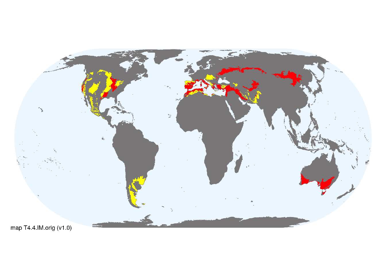
Map description
Terrestrial ecoregions containing major or minor occurrences of this ecosystem functional group were identified by consulting available ecoregion descriptions (Dinerstein et al. 2017), global and regional reviews, national and regional ecosystem maps, locations of relevant examples, and proofed by expert reviewers. Consequently they are coarse-scale indicative representations of distribution, except where they occupy small ecoregions. Ecoregions were mapped at 30 arc second spatial resolution..
Map code and version: T4.4.web.orig v1.0, available at ![]()
Version history
Profile versions
- v2.1 (2022-04-06): DA Keith; D Faber-Langendoen; J Franklin.1
- v2.01 (2021-12-31): NA.
- v2.0 (2020-09-04): DA Keith; D Faber-Langendoen; J Franklin.
- v1.0 (2020-01-20): DA Keith; D Faber-Langendoen; J Franklin.
Available maps
Read more details about the current map versions here.
- Web navigation (code: T4.4.web.orig, version v1.0)

- Indicative Map (code: T4.4.IM.orig, version v1.0)
Read more details about older or alternative versions of maps for this functional group.
- Indicative Map: discarded (code: T4.4.IM.mix, version v1.0)
References
Main references
References used in the different versions of the profiles.
- Davis FW, Baldocchi DD, Tyler CM (2019) Oak woodlands Ecosystems of California (Eds. HA Mooney, E Zavaleta). Chapter 25 pp 509-534. University of California Press, Berkeley DOI:10.1525/9780520962170-029
- Gibson GJ (2009) Grasses and grassland ecology Oxford University Press, Oxford
- Prober SM, Gosper CR, Gilfedder L, Harwood TD, Thiele KR, Williams KJ, Yates CJ (2017) Temperate eucalypt woodlands Australian vegetation (Ed. DA Keith), pp 410-437. Cambridge University Press, Cambridge. ISBN 978-1-107-11843-0
Map references
References used in the different versions of the maps (current and discarded).
- Dinerstein E, Olson D, Joshi A, Vynne C, Burgess ND, Wikramanayake E, Hahn N, Palminteri S, Hedao P, Noss R, Hansen M, Locke H, Ellis EE, Jones B, Barber CV, Hayes R, Kormos C, Martin V, Crist E, Sechrest W, Price L, Baillie JEM, Weeden D, Suckling K, Davis C, Sizer N, Moore R, Thau D, Birch T, Potapov P, Turubanova S, Tyukavina A, de Souza N, Pintea L, Brito JC, Llewellyn Barnekow Lillesø JP, van Breugel P, Graudal L, Voge M, Al-Shammari KF, Saleem M (2017) An Ecoregion-Based Approach to Protecting Half the Terrestrial Realm, BioScience 67: 534–545. DOI:10.1093/biosci/bix014. Data-set available on-line
- Tuanmu, M.-N. and W. Jetz (2014) A global 1-km consensus land-cover product for biodiversity and ecosystem modeling Global Ecology and Biogeography 23(9):1031–1045 DOI:10.1111/geb.12182
Footnotes
This is the current version available at official site.↩︎