T4.2 Pyric tussock savannas
T4. Savannas and grasslands biome
T4
Profile summary
Full profile at https://global-ecosystems.org/explore/groups/T4.2
Brief description
In pyric savannas, recurring fire is the principal agent that limits tree dominance and maintains tree-grass coexistence. Dominated by tussock grasses that grow tall during high-productivity wet summers and cure over dry winter seasons, these ecosystems occur on all major land masses at tropical and subtropical latitudes around the world. Large mammalian herbivores are usually present, but not at densities that limit grass growth or mediate tree-grass coexistence (unlike T4.1). Many plants have traits that promote tolerate of seasonal drought, such as deciduous leaf phenology, subterranean storage organs and deep roots. Invertebrate detritivores, notably termites, and vertebrate scavengers are key groups in the foodweb.
Key features
Grasslands and grassy woodlands dominated by C4 tussock grasses. Strong seasonal (winter) drought, low fertility, and fires major consumer of biomass..
Overview of distribution
Global wet/dry tropics & subtropics.
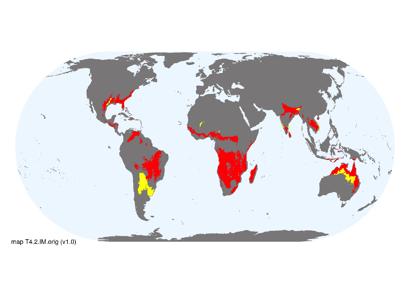
Map description
Terrestrial ecoregions containing major or minor occurrences of this ecosystem functional group were identified by consulting available ecoregion descriptions (Dinerstein et al. 2017), global and regional reviews, national and regional ecosystem maps, locations of relevant examples, and proofed by expert reviewers. Consequently they are coarse-scale indicative representations of distribution, except where they occupy small ecoregions. Ecoregions were mapped at 30 arc second spatial resolution..
Map code and version: T4.2.web.orig v1.0, available at ![]()
Version history
Profile versions
- v2.1 (2022-04-06): CER Lehmann; A Etter; KR Young; DA Keith.1
- v2.01 (2021-12-31): NA.
- v2.0 (2020-06-15): CER Lehmann; A Etter; KR Young; DA Keith.
- v1.0 (2020-01-20): CER Lehmann; A Etter; DA Keith.
Available maps
Read more details about the current map versions here.
- Web navigation (code: T4.2.web.orig, version v1.0)

- Indicative Map (code: T4.2.IM.orig, version v1.0)
Read more details about older or alternative versions of maps for this functional group.
- Indicative Map: discarded (code: T4.2.IM.mix, version v1.0)
References
Main references
References used in the different versions of the profiles.
- Furley PA (1999) The nature and diversity of neotropical savanna vegetation with particular reference to the Brazilian cerrados Global Ecology and Biogeography 8, 223-241
- Lehmann CER, Anderson TM, Sankaran M, Higgins SI, Archibald S, Hoffmann WA, et al. (2014). Savanna vegetation-fire-climate relationships differ among continents. Science 343, 548-552.
Map references
References used in the different versions of the maps (current and discarded).
- Dinerstein E, Olson D, Joshi A, Vynne C, Burgess ND, Wikramanayake E, Hahn N, Palminteri S, Hedao P, Noss R, Hansen M, Locke H, Ellis EE, Jones B, Barber CV, Hayes R, Kormos C, Martin V, Crist E, Sechrest W, Price L, Baillie JEM, Weeden D, Suckling K, Davis C, Sizer N, Moore R, Thau D, Birch T, Potapov P, Turubanova S, Tyukavina A, de Souza N, Pintea L, Brito JC, Llewellyn Barnekow Lillesø JP, van Breugel P, Graudal L, Voge M, Al-Shammari KF, Saleem M (2017) An Ecoregion-Based Approach to Protecting Half the Terrestrial Realm, BioScience 67: 534–545. DOI:10.1093/biosci/bix014. Data-set available on-line
- Tuanmu, M.-N. and W. Jetz (2014) A global 1-km consensus land-cover product for biodiversity and ecosystem modeling Global Ecology and Biogeography 23(9):1031–1045 DOI:10.1111/geb.12182
Footnotes
This is the current version available at official site.↩︎