T3.4 Young rocky pavements, lava flows and screes
T3. Shrublands and shrubby woodlands biome
T3
Profile summary
Full profile at https://global-ecosystems.org/explore/groups/T3.4
Brief description
With a scattered distribution globally, these young rocky ecosystems are exposed to extreme temperatures, weathering and disturbance, and have limited capacity to retain water and nutrients. Analogues in icy environments belong to T6.2. Productivity and diversity are consequently low. Lichens and mosses are often abundant and important to ecosystem development, slowly building soils through incremental retention of moisture and nutrients. Successional development of soils and vegetation may be interrupted by landslides, eruptions and other mass movements. Small-leaved pioneer shrubs and grasses are sparse, often growing in crevices. The simple foodwebs are comprised mainly of microbes and itinerant organisms, with few resident vertebrates other than reptiles and ground-nesting birds.
Key features
Low-diversity cryptogam-dominated systems with scattered herbs and shrubs on skeletal substrates with limited nutrients and moisture.
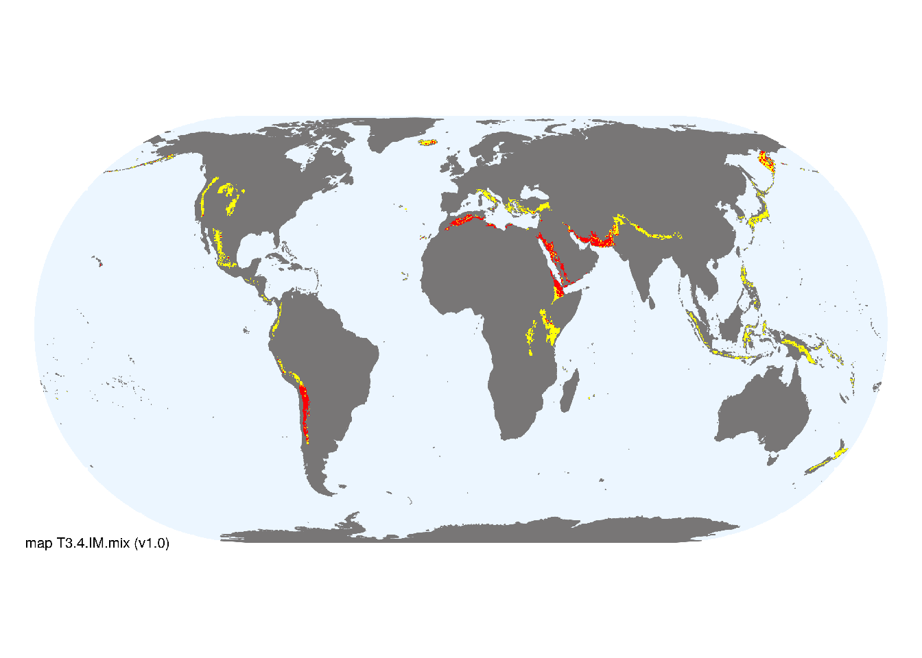
Overview of distribution
Around the Pacific Rim, African Rift Valley, Mediterranean and north Atlantic.
Map description
Major and minor occurrences were initially identified using consensus land-cover maps (Tuanmu et al. 2014) and then cropped to selected terrestrial ecoregions (Dinerstein et al. 2017) at 30 arc seconds spatial resolution. Ecoregions were selected if: i) their descriptions mentioned features consistent with those identified in the profile of the Ecosystem Functional Group; and ii) if their location was consistent with the ecological drivers described in the profile..
Map code and version: T3.4.web.mix v1.0, available at ![]()
Version history
Profile versions
- v2.1 (2022-04-06): DA Keith; NA Cutler.1
- v2.01 (2021-12-31): NA.
- v2.0 (2020-06-15): DA Keith; NA Cutler.
- v1.0 (2020-01-20): DA Keith.
Available maps
Read more details about the current map versions here.
- Web navigation (code: T3.4.web.mix, version v1.0)

- Indicative Map (code: T3.4.IM.mix, version v1.0)
Read more details about older or alternative versions of maps for this functional group.
- Indicative Map: discarded (code: T3.4.IM.orig, version v1.0)
- Web navigation: requires review (code: T3.4.web.orig, version v1.0)
References
Main references
References used in the different versions of the profiles.
- Anderson-Teixeira KJ, Vitousek PM, Brown JH (2007) Amplified temperature dependence in ecosystems developing on the lava flows of Mauna Loa, Hawai’i PNAS 105: 228-233 DOI:pnas.0710214104
- Crews TE, Kurina, LM, Vitousek PM (2001) Organic matter and nitrogen accumulation and nitrogen fixation during early ecosystem development in Hawaii Biogeochemistry 52: 259-279 DOI:10.1023/A:1006441726650
- Cutler NA, Belyea LR, Dugmore AJ (2008) The spatiotemporal dynamics of a primary succession Journal of Ecology 96: 231-246
Map references
References used in the different versions of the maps (current and discarded).
- Dinerstein E, Olson D, Joshi A, Vynne C, Burgess ND, Wikramanayake E, Hahn N, Palminteri S, Hedao P, Noss R, Hansen M, Locke H, Ellis EE, Jones B, Barber CV, Hayes R, Kormos C, Martin V, Crist E, Sechrest W, Price L, Baillie JEM, Weeden D, Suckling K, Davis C, Sizer N, Moore R, Thau D, Birch T, Potapov P, Turubanova S, Tyukavina A, de Souza N, Pintea L, Brito JC, Llewellyn Barnekow Lillesø JP, van Breugel P, Graudal L, Voge M, Al-Shammari KF, Saleem M (2017) An Ecoregion-Based Approach to Protecting Half the Terrestrial Realm, BioScience 67: 534–545. DOI:10.1093/biosci/bix014. Data-set available on-line
- Tuanmu, M.-N. and W. Jetz (2014) A global 1-km consensus land-cover product for biodiversity and ecosystem modeling Global Ecology and Biogeography 23(9):1031–1045 DOI:10.1111/geb.12182
Footnotes
This is the current version available at official site.↩︎