T3.2 Seasonally dry temperate heath and shrublands
T3. Shrublands and shrubby woodlands biome
T3
Profile summary
Full profile at https://global-ecosystems.org/explore/groups/T3.2
Brief description
These temperate ecosystems are dominated by sclerophyll shrubs with small or ericoid leaves. A low sparse tree canopy may or may not be present. Low-moderate productivity is limited by summer droughts and low nutrient availability. and sandy or loamy soils, with many diverse plant specialisations to low nutrient, and regular fires, accelerated by slow decomposition rates. Foodwebs vary from complex to simple, but most lack large herbivores and predators. Vertebrate herbivores have specialisations to exploit low nutrient vegetation and avoid recurring fires, which are influential on plant and animal life histories. Specific plant-invertebrate relationships (e.g. as larval hosts and pollinators) are common (moths and butterflies larval hosts, wasp pollinators).
Key features
Sclerophyll evergreen shrublands of humid and subhumid mid-latitudes with a canopy-fire regime.
Overview of distribution
Temperate regions adjacent to cold ocean currents with summer dry season.
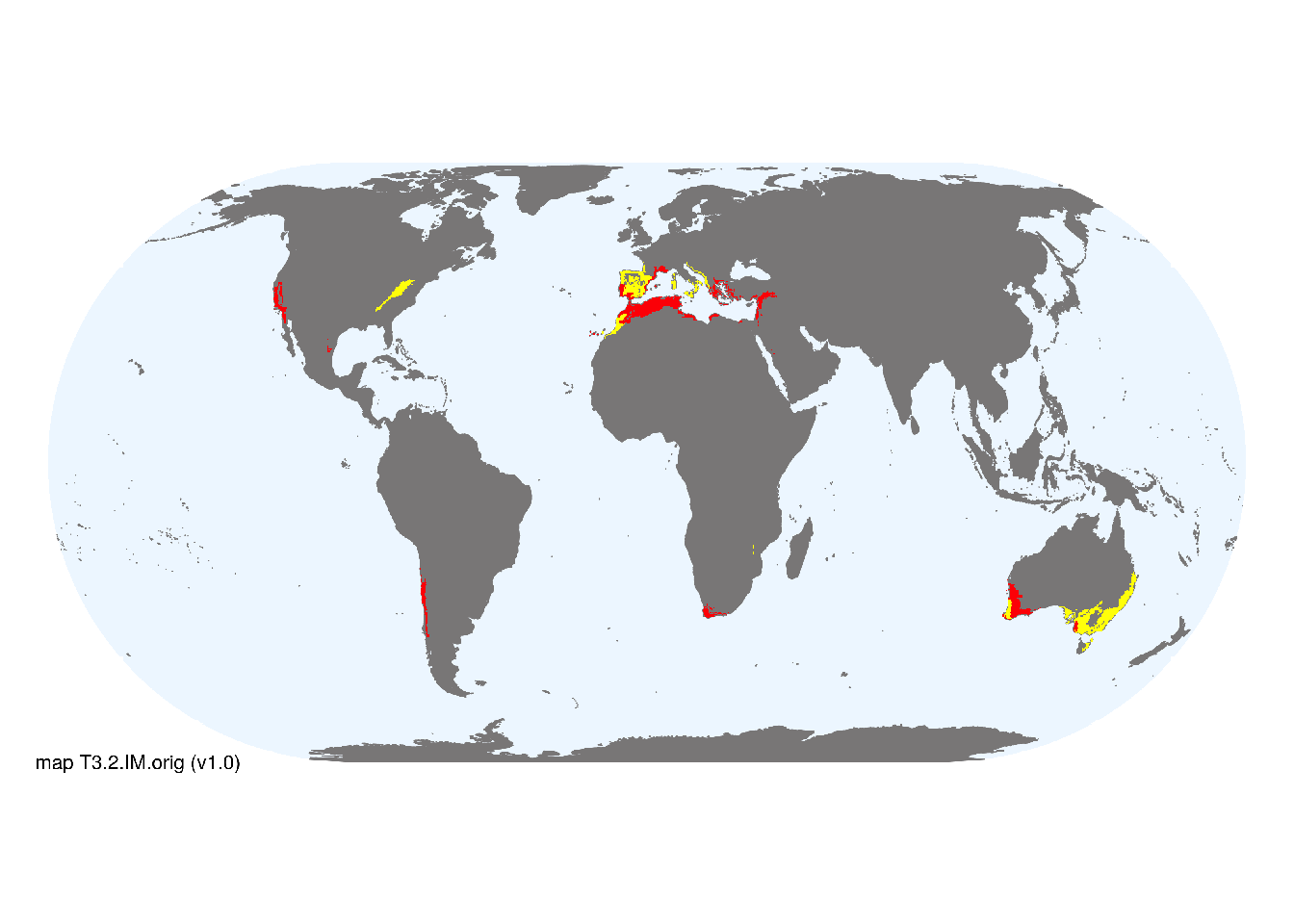
Map description
Terrestrial ecoregions containing major or minor occurrences of this ecosystem functional group were identified by consulting available ecoregion descriptions (Dinerstein et al. 2017), global and regional reviews, national and regional ecosystem maps, locations of relevant examples, and proofed by expert reviewers. Consequently they are coarse-scale indicative representations of distribution, except where they occupy small ecoregions. Ecoregions were mapped at 30 arc second spatial resolution..
Map code and version: T3.2.web.orig v1.0, available at ![]()
Version history
Profile versions
- v2.1 (2022-04-06): DA Keith; J Loidi.1
- v2.01 (2021-12-31): NA.
- v2.0 (2020-05-31): DA Keith; J Loidi.
- v1.0 (2020-01-20): DA Keith.
Available maps
Read more details about the current map versions here.
- Web navigation (code: T3.2.web.orig, version v1.0)

- Indicative Map (code: T3.2.IM.orig, version v1.0)
Read more details about older or alternative versions of maps for this functional group.
- Indicative Map: discarded (code: T3.2.IM.alt, version v2.1)
- Indicative Map: requires review (code: T3.2.IM.orig, version v2.0)
- Indicative Map: discarded (code: T3.2.IM.mix, version v1.0)
References
Main references
References used in the different versions of the profiles.
- Keeley JE, Bond WJ, Bradstock RA, Pausas, JG, Rundel PW (2012) Fire in Mediterranean Ecosystems: ecology, evolution and management Cambridge University Press, Cambridge
- Lamont BB, Keith DA (2017) Heathlands and associated shrublands Australian vegetation (Ed. DA Keith), pp 339-368. Cambridge University Press, Cambridge. ISBN 978-1-107-11843-0
Map references
References used in the different versions of the maps (current and discarded).
- Dinerstein E, Olson D, Joshi A, Vynne C, Burgess ND, Wikramanayake E, Hahn N, Palminteri S, Hedao P, Noss R, Hansen M, Locke H, Ellis EE, Jones B, Barber CV, Hayes R, Kormos C, Martin V, Crist E, Sechrest W, Price L, Baillie JEM, Weeden D, Suckling K, Davis C, Sizer N, Moore R, Thau D, Birch T, Potapov P, Turubanova S, Tyukavina A, de Souza N, Pintea L, Brito JC, Llewellyn Barnekow Lillesø JP, van Breugel P, Graudal L, Voge M, Al-Shammari KF, Saleem M (2017) An Ecoregion-Based Approach to Protecting Half the Terrestrial Realm, BioScience 67: 534–545. DOI:10.1093/biosci/bix014. Data-set available on-line
- Martin Jung, Prabhat Raj Dahal, Stuart H. M. Butchart, Paul F. Donald, Xavier De Lamo, Myroslava Lesiv, … Piero Visconti. (2020). A global map of terrestrial habitat types [Data set]. Zenodo. DOI: 10.5281/zenodo.3673586
- Tuanmu, M.-N. and W. Jetz (2014) A global 1-km consensus land-cover product for biodiversity and ecosystem modeling Global Ecology and Biogeography 23(9):1031–1045 DOI:10.1111/geb.12182
Footnotes
This is the current version available at official site.↩︎