T2.1 Boreal and temperate high montane forests and woodlands
T2. Temperate-boreal forests and woodlands biome
T2
Profile summary
Full profile at https://global-ecosystems.org/explore/groups/T2.1
Brief description
In boreal and mountainous cold, seasonally snow-prone climates, acid soils support structurally simple forests made up of needle-leaf conifer trees, sometimes with broad-leaf deciduous trees. Large forest trees provide habitat for fungi, mosses and liverworts. Seasonal understorey growth sustains high densities of herbivores such as bear, deer, and a variety of insects, with predators such as lynx, wolves and raptors. Plants and animals survive cold winters through freeze-tolerant organs, hibernation or migratory movements.
Key features
Closed to open, evergreen (conifers) or deciduous forests in cold climates with short growth periods, low vascular plant species diversity, but abundant cryptogams.
Overview of distribution
Cool regions (boreal zone or mountains in temperate or mediterranean regions) of the Northern Hemisphere, limited occurrences in southern South America.
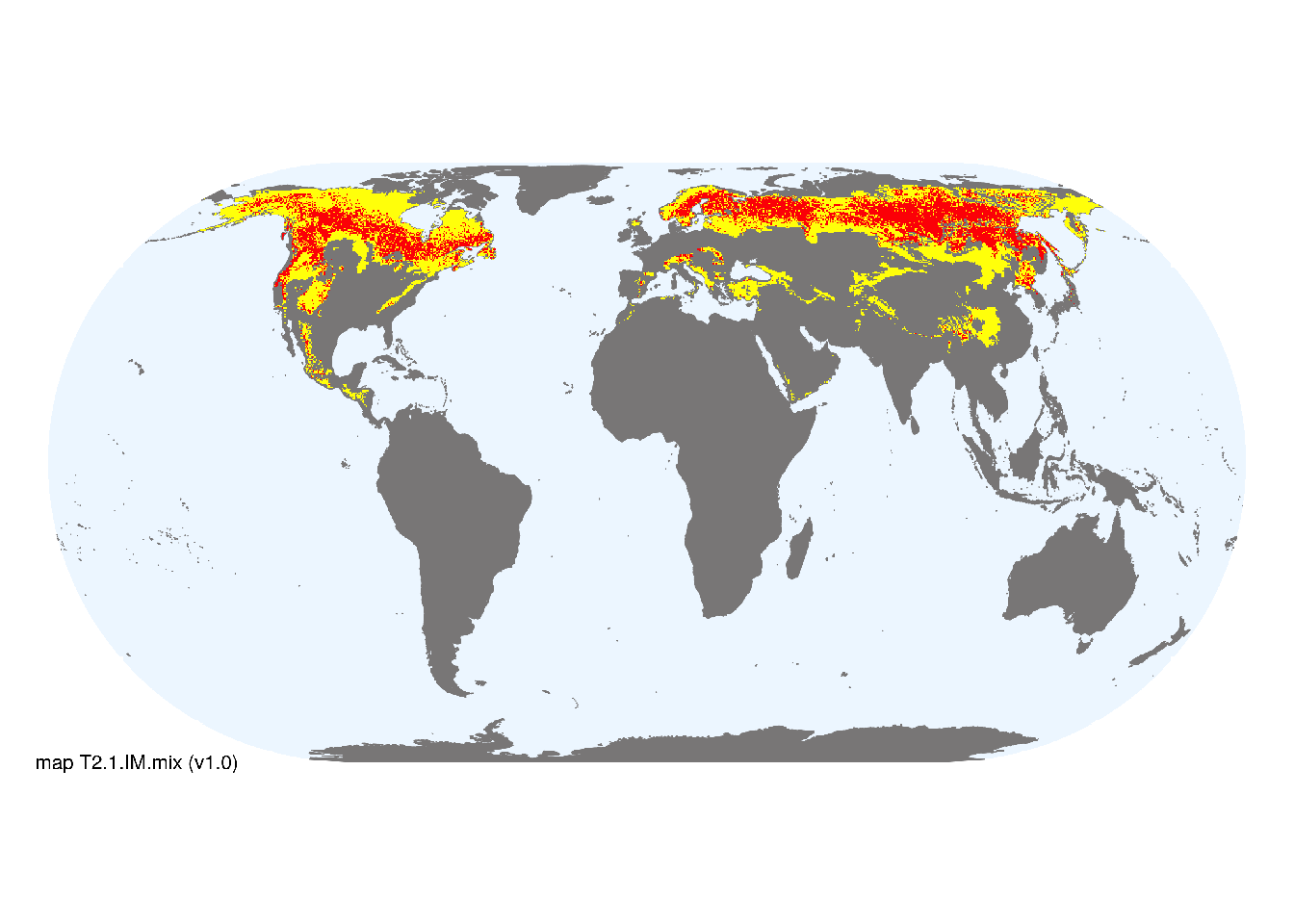
Map description
Major and minor occurrences were initially identified using consensus land-cover maps (Tuanmu et al. 2014) and then cropped to selected terrestrial ecoregions (Dinerstein et al. 2017) at 30 arc seconds spatial resolution. Ecoregions were selected if: i) their descriptions mentioned features consistent with those identified in the profile of the Ecosystem Functional Group; and ii) if their location was consistent with the ecological drivers described in the profile..
Map code and version: T2.1.web.mix v1.0, available at ![]()
Version history
Profile versions
- v2.1 (2022-04-06): DA Keith; D Faber-Langendoen; T Kontula; J Franklin; NA Brummitt.1
- v2.01 (2021-12-31): NA.
- v2.0 (2020-06-15): DA Keith; D Faber-Langendoen; T Kontula; J Franklin; NA Brummitt.
- v1.0 (2020-01-20): DA Keith; D Faber-Langendoen; T Kontula; J Franklin; NA Brummitt.
Available maps
Read more details about the current map versions here.
- Web navigation (code: T2.1.web.mix, version v1.0)

- Indicative Map (code: T2.1.IM.mix, version v1.0)
Read more details about older or alternative versions of maps for this functional group.
- Indicative Map: superceeded (code: T2.1.IM.alt, version v2.1)
- Indicative Map: superceded (code: T2.1.IM.orig, version v1.0)
- Web navigation: requires review (code: T2.1.web.orig, version v1.0)
References
Main references
References used in the different versions of the profiles.
- Bonan GB, Shugart HH (1989) Environmental Factors and Ecological Processes in Boreal Forests. Annual Review of Ecology and Systematics 20: 1-28. DOI:10.1146/annurev.es.20.110189.000245
- Crawford RMM (2013) Tundra-taiga biology. Ch 5. Oxford University Press, Oxford.
- Larsen JA (1980) The boreal ecosystem. Academic Press, New York.
Map references
References used in the different versions of the maps (current and discarded).
- Dinerstein E, Olson D, Joshi A, Vynne C, Burgess ND, Wikramanayake E, Hahn N, Palminteri S, Hedao P, Noss R, Hansen M, Locke H, Ellis EE, Jones B, Barber CV, Hayes R, Kormos C, Martin V, Crist E, Sechrest W, Price L, Baillie JEM, Weeden D, Suckling K, Davis C, Sizer N, Moore R, Thau D, Birch T, Potapov P, Turubanova S, Tyukavina A, de Souza N, Pintea L, Brito JC, Llewellyn Barnekow Lillesø JP, van Breugel P, Graudal L, Voge M, Al-Shammari KF, Saleem M (2017) An Ecoregion-Based Approach to Protecting Half the Terrestrial Realm, BioScience 67: 534–545. DOI:10.1093/biosci/bix014. Data-set available on-line
- Martin Jung, Prabhat Raj Dahal, Stuart H. M. Butchart, Paul F. Donald, Xavier De Lamo, Myroslava Lesiv, … Piero Visconti. (2020). A global map of terrestrial habitat types [Data set]. Zenodo. DOI: 10.5281/zenodo.3673586
- Tuanmu, M.-N. and W. Jetz (2014) A global 1-km consensus land-cover product for biodiversity and ecosystem modeling Global Ecology and Biogeography 23(9):1031–1045 DOI:10.1111/geb.12182
Footnotes
This is the current version available at official site.↩︎