T1.3 Tropical/Subtropical montane rainforests
T1. Tropical-subtropical forests biome
T1
Profile summary
Full profile at https://global-ecosystems.org/explore/groups/T1.3
Brief description
These mountain rainforests are characterised by a single-layered tree canopy, with epiphytic ferns, bryophytes, lichens, orchids, and bromeliads draping tree branches. Grasses are rare or absent. At high altitude forest structure becomes less complex, with dwarf tree forms. Although rainfall is abundant (up to 6000 mm per year), productivity is limited by cool temperatures, wind exposure and shallow soils, although under the canopy a moist shady microclimate provides stable habitat for a frog, bird, plant and invertebrate species that are found nowhere else.
Key features
Closed-canopy evergreen forests with abundant non-vascular epiphytes in warm/cool wet cloudy climates, diverse life forms.
Overview of distribution
Global tropical & subtropical mountains.
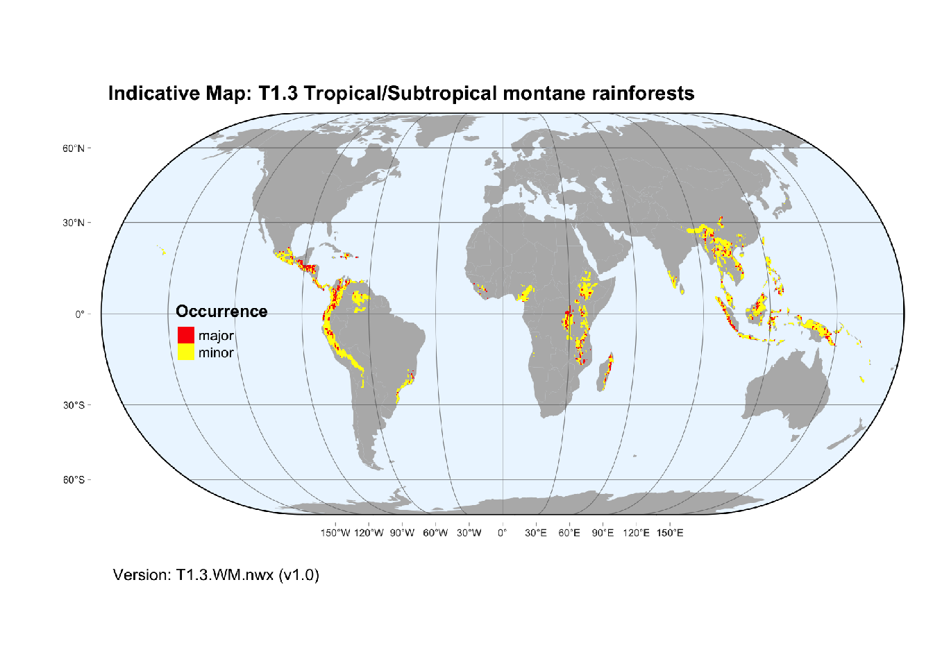
Map description
The distribution of tropical montane rainforest was approximated from a model of environmental suitability based on climatic variables and cloud cover (Wilson and Jetz, 2016, Karger et al. 2021). Occurrences were aggregated to half degree spatial resolution and cells reclassified as major occurrences (>25% of cell area) and minor occurrences (< 25% of cell area)..
Map code and version: T1.3.WM.nwx v1.0, available at ![]()
Version history
Profile versions
- v2.1 (2022-04-06): DA Keith; NA Brummitt; KR Young; RT Corlett; A Etter.1
- v2.01 (2021-12-31): NA.
- v2.0 (2020-06-15): DA Keith; NA Brummitt; KR Young; RT Corlett; A Etter.
- v1.0 (2020-01-20): DA Keith; NA Brummitt; A Etter.
Available maps
Read more details about the current map versions here.
- Web navigation (code: T1.3.web.alt, version v2.1)

- Indicative Map (code: T1.3.WM.nwx, version v1.1)

Read more details about older or alternative versions of maps for this functional group.
- Indicative Map: discarded (code: T1.3.IM.alt, version v2.2)
- Indicative Map: superceeded (code: T1.3.IM.alt, version v2.1)
- Indicative Map: discarded (code: T1.3.IM.alt, version v2.0)
- Indicative Map: replaced (code: T1.3.WM.nwx, version v1.0)

- Indicative Map: discarded (code: T1.3.IM.orig, version v1.0)
- Web navigation: requires review (code: T1.3.web.orig, version v1.0)
- Web navigation: requires review (code: T1.3.web, version v1.0)
References
Main references
References used in the different versions of the profiles.
- Ashton PS, Seidler R (2014) On the forests of tropical Asia: lest the memory fade Kew Publishing: Kew
- Gradstein SR, Homeier J, Gansert D (2008) The tropical mountain forest – patterns and processes in a biodiversity hotspot The tropical mountain forest – patterns and processes in a biodiversity hotspot Biodiversity and Ecology Series 2. Göttingen, Centre for Biodiversity and Ecology DOI:10.17875/gup2008-702
- Hamilton LS, Juvik JO, Scatena FN (1995) Tropical Montane Cloud Forests Ecological Studies 110. Springer-Verlag, Berlin
Map references
References used in the different versions of the maps (current and discarded).
- Dinerstein E, Olson D, Joshi A, Vynne C, Burgess ND, Wikramanayake E, Hahn N, Palminteri S, Hedao P, Noss R, Hansen M, Locke H, Ellis EE, Jones B, Barber CV, Hayes R, Kormos C, Martin V, Crist E, Sechrest W, Price L, Baillie JEM, Weeden D, Suckling K, Davis C, Sizer N, Moore R, Thau D, Birch T, Potapov P, Turubanova S, Tyukavina A, de Souza N, Pintea L, Brito JC, Llewellyn Barnekow Lillesø JP, van Breugel P, Graudal L, Voge M, Al-Shammari KF, Saleem M (2017) An Ecoregion-Based Approach to Protecting Half the Terrestrial Realm, BioScience 67: 534–545. DOI:10.1093/biosci/bix014. Data-set available on-line
- Martin Jung, Prabhat Raj Dahal, Stuart H. M. Butchart, Paul F. Donald, Xavier De Lamo, Myroslava Lesiv, … Piero Visconti. (2020). A global map of terrestrial habitat types [Data set]. Zenodo. DOI: 10.5281/zenodo.3673586
- Karger, D.N., Conrad, O., Böhner, J., Kawohl, T., Kreft, H., Soria-Auza, R.W., Zimmermann, N.E., Linder, H.P. & Kessler, M. (2017) Climatologies at high resolution for the earth’s land surface areas. Scientific Data 4, 170122.
- Karger, D.N., Kessler, M., Lehnert, M. et al. (2021) Limited protection and ongoing loss of tropical cloud forest biodiversity and ecosystems worldwide Nat Ecol Evol DOI:10.1038/s41559-021-01450-y
- Körner C, Paulsen J, Spehn E (2011) A definition of mountains and their bioclimatic belts for global comparisons of biodiversity data. Alpine Botany 121(2): 73-78 and the dataset DOI: 10.7892/boris.83486.
- Tuanmu, M.-N. and W. Jetz (2014) A global 1-km consensus land-cover product for biodiversity and ecosystem modeling Global Ecology and Biogeography 23(9):1031–1045 DOI:10.1111/geb.12182
- Wilson AM, Jetz W (2016) Remotely Sensed High-Resolution Global Cloud Dynamics for Predicting Ecosystem and Biodiversity Distributions. PLoS Biol 14(3): e1002415. doi:10.1371/journal.pbio.1002415. Dataset available on-line
Footnotes
This is the current version available at official site.↩︎