T1.2 Tropical/Subtropical dry forests and thickets
T1. Tropical-subtropical forests biome
T1
Profile summary
Full profile at https://global-ecosystems.org/explore/groups/T1.2
Brief description
Tropical-subtropical dry forests and thickets are characterised by fertile substrates and seasonally dry conditions (~1800 mm per year, with a period of 3 to 6 months receiving less than 100 mm per month) that drive markedly seasonal patterns of productivity. Tree-diversity is high, with a variable mixture of evergreen and drought-deciduous trees, with abundant vines, but fewer epiphytes, ferns, mosses, and forbs, limited by seasonal drought. Abundant leaf litter is decomposed by fungi and microbes within complex foodwebs dominated by vertebrates of all kinds.
Key features
Closed-canopy deciduous and semi-deciduous forests in warm seasonally wet/dry climates, diverse life forms.
Overview of distribution
Global wet/dry tropics & subtropics.
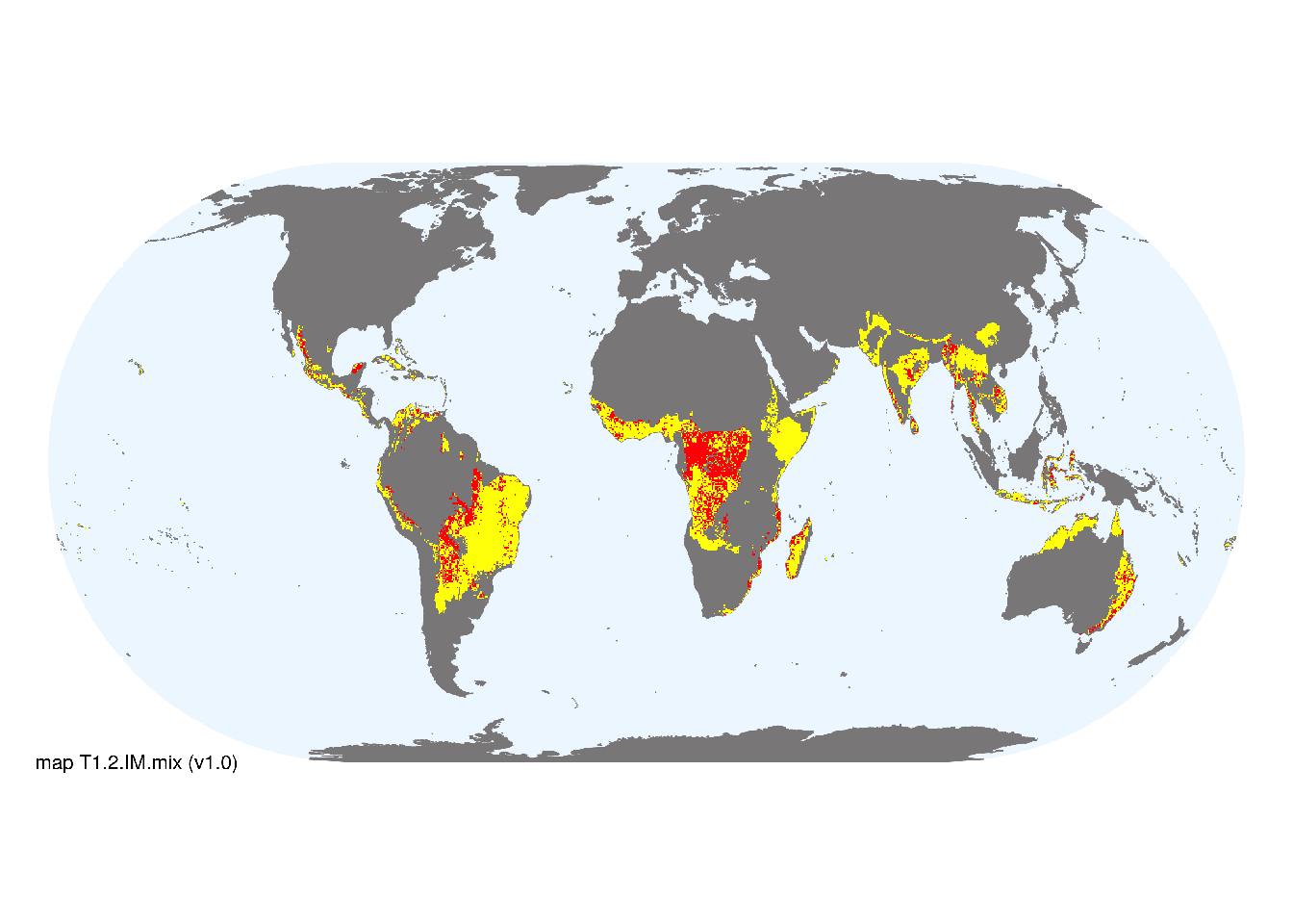
Map description
Major and minor occurrences were initially identified using consensus land-cover maps (Tuanmu et al. 2014) and then cropped to selected terrestrial ecoregions (Dinerstein et al. 2017) at 30 arc seconds spatial resolution. Ecoregions were selected if: i) their descriptions mentioned features consistent with those identified in the profile of the Ecosystem Functional Group; and ii) if their location was consistent with the ecological drivers described in the profile..
Map code and version: T1.2.web.mix v1.0, available at ![]()
Version history
Profile versions
- v2.1 (2022-04-06): RT Pennington; J Franklin; NA Brummitt; A Etter; KR Young; RT Corlett; DA Keith.1
- v2.01 (2021-12-31): NA.
- v2.0 (2020-05-31): RT Pennington; J Franklin; NA Brummitt; A Etter; KR Young; RT Corlett; DA Keith.
- v1.0 (2020-01-20): RT Pennington; J Franklin; NA Brummitt; A Etter; DA Keith.
Available maps
Read more details about the current map versions here.
- Web navigation (code: T1.2.web.mix, version v1.0)

- Indicative Map (code: T1.2.IM.mix, version v1.0)
Read more details about older or alternative versions of maps for this functional group.
- Indicative Map: discarded (code: T1.2.IM.alt, version v2.1)
- Indicative Map: discarded (code: T1.2.IM.alt, version v2.0)
- Web navigation: in preparation (code: T1.2.WM.nwx, version v1.0)
- Web navigation: requires review (code: T1.2.web.orig, version v1.0)
- Web navigation: requires review (code: T1.2.web, version v1.0)
- Indicative Map: replaced (code: T1.2.IM.orig, version v1.0)
References
Main references
References used in the different versions of the profiles.
- Bunyavejchewin SC, Baker P, Davis SJ (2011) Seasonally dry tropical forests in continental southeast Asia - structure, composition, and dynamics The ecology and conservation of seasonally dry forests in Asia WJ McShea, SJ Davis, N Bhumpakphan, (Eds), pp. 9-35. Smithsonian Institution Scholarly Press, Washington DC. ISBN 9781935623021
- DRYFLOR, Banda-R K, Delgado-Salinas A, Dexter KG et al. (2016) Plant diversity patterns in neotropical dry forests and their conservation implications Science 353:1383-1387 DOI:10.1126/science.aaf5080
- Murphy PG, Lugo AE (1986) Ecology of tropical dry forest Annual Review of Ecology and Systematics 17:67–88 DOI:10.1146/annurev.es.17.110186.000435
- Pennington RT, Lewis G, Ratter J (2006) Neotropical savannas and dry forests: plant diversity, biogeography and conservation CRC Press, Florida
Map references
References used in the different versions of the maps (current and discarded).
- Beck, H., Zimmermann, N., McVicar, T. et al. (2018) Present and future Köppen-Geiger climate classification maps at 1-km resolution Sci Data 5, 180214 DOI:10.1038/sdata.2018.214
- Dinerstein E, Olson D, Joshi A, Vynne C, Burgess ND, Wikramanayake E, Hahn N, Palminteri S, Hedao P, Noss R, Hansen M, Locke H, Ellis EE, Jones B, Barber CV, Hayes R, Kormos C, Martin V, Crist E, Sechrest W, Price L, Baillie JEM, Weeden D, Suckling K, Davis C, Sizer N, Moore R, Thau D, Birch T, Potapov P, Turubanova S, Tyukavina A, de Souza N, Pintea L, Brito JC, Llewellyn Barnekow Lillesø JP, van Breugel P, Graudal L, Voge M, Al-Shammari KF, Saleem M (2017) An Ecoregion-Based Approach to Protecting Half the Terrestrial Realm, BioScience 67: 534–545. DOI:10.1093/biosci/bix014. Data-set available on-line
- Martin Jung, Prabhat Raj Dahal, Stuart H. M. Butchart, Paul F. Donald, Xavier De Lamo, Myroslava Lesiv, … Piero Visconti. (2020). A global map of terrestrial habitat types [Data set]. Zenodo. DOI: 10.5281/zenodo.3673586
- Miles, L. et al. (2006) A global overview of the conservation status of tropical dry forests Journal of biogeography 33(3), pp.491—505 DOI:10.1111/j.1365-2699.2005.01424.x
- Ocón, J. P. (2020) A Global Analysis of Tropical Dry Forest Extent and Cover Based on Climatic Definitions UCLA. ProQuest ID: OcxF3n_ucla_0031N_18845. Merritt ID: ark:/13030/m5sf84cm. Retrieved from https://escholarship.org/uc/item/3ng2j2vn
- Tuanmu, M.-N. and W. Jetz (2014) A global 1-km consensus land-cover product for biodiversity and ecosystem modeling Global Ecology and Biogeography 23(9):1031–1045 DOI:10.1111/geb.12182
Footnotes
This is the current version available at official site.↩︎