T1.1 Tropical/Subtropical lowland rainforests
T1. Tropical-subtropical forests biome
T1
Profile summary
Full profile at https://global-ecosystems.org/explore/groups/T1.1
Brief description
A huge diversity of species occupy niches within a complex vertically-layered structure of plant forms. High productivity is fuelled by rapid-growing plants including buttressed trees, bamboos, epiphytes, lianas and ferns. Forest canopies sustain moist soils and abundant leaf litter decomposed by fungi and bacteria. High diversity of invertebrates at all levels of the forest supports diverse vertebrate life forms, particularly mammals and birds, which play critical roles in plant dispersal and pollination. Conditions near the equator are stable and humid year-round (up to 6000 mm rain per annum), but become more seasonal with mild winter frosts in the subtropics.
Key features
Tall closed-canopy evergreen forests in warm wet climates, phylogenetically & functionally highly diverse life forms.
Overview of distribution
Global wet tropics & subtropics.
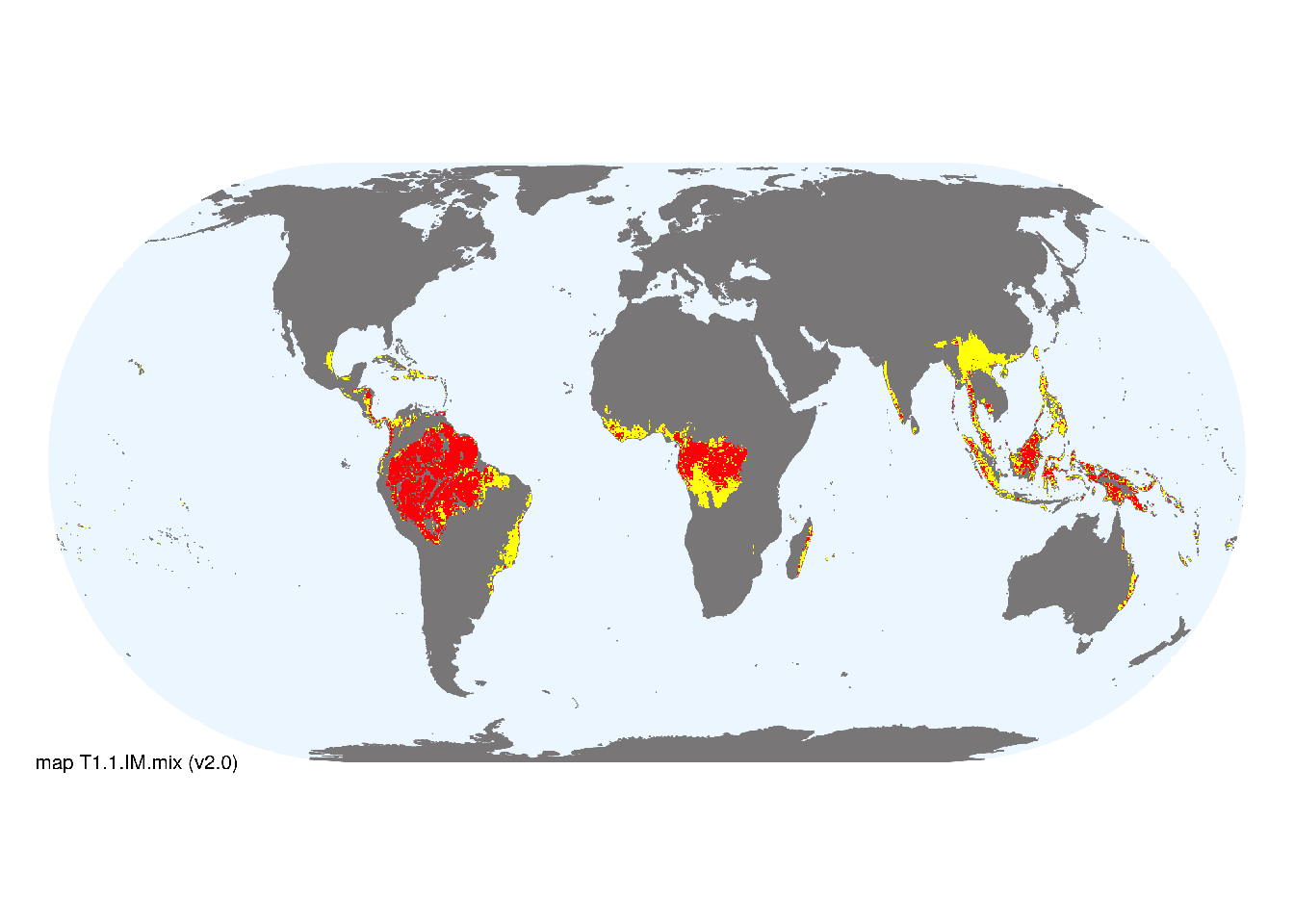
Map description
Major and minor occurrences were initially identified using consensus land-cover maps (Tuanmu et al. 2014) and then cropped to selected terrestrial ecoregions (Dinerstein et al. 2017; DAWE 2012) at 30 arc seconds spatial resolution. Ecoregions were selected if: i) their descriptions mentioned features consistent with those identified in the profile of the Ecosystem Functional Group; and ii) if their location was consistent with the ecological drivers described in the profile..
Map code and version: T1.1.web.mix v2.0, available at ![]()
Version history
Profile versions
- v2.1 (2022-04-06): DA Keith; KR Young; RT Corlett.1
- v2.01 (2021-12-31): NA.
- v2.0 (2020-06-15): DA Keith; KR Young; RT Corlett.
- v1.0 (2020-01-20): DA Keith.
Available maps
Read more details about the current map versions here.
- Indicative Map (code: T1.1.IM.mix, version v2.0)
- Web navigation (code: T1.1.web.mix, version v2.0)

Read more details about older or alternative versions of maps for this functional group.
- Indicative Map: discarded (code: T1.1.IM.alt, version v2.1)
- Indicative Map: discarded (code: T1.1.IM.alt, version v2.0)
- Indicative Map: discarded (code: T1.1.IM.orig, version v1.0)
- Indicative Map: discarded (code: T1.1.IM.mix, version v1.0)
- Web navigation: discarded (code: T1.1.web.mix, version v1.0)
- Web navigation: requires review (code: T1.1.web, version v1.0)
- Web navigation: requires review (code: T1.1.web.orig, version v1.0)
References
Main references
References used in the different versions of the profiles.
- Ashton PS, Seidler R (2014) On the forests of tropical Asia: lest the memory fade Kew Publishing: Kew
- Corlett RT, Primack RB (2011) Tropical Rain Forests: An ecological and biogeographical comparison. Second edition. Wiley-Blackwell, Chichester.
Map references
References used in the different versions of the maps (current and discarded).
- Beck, H., Zimmermann, N., McVicar, T. et al. (2018) Present and future Köppen-Geiger climate classification maps at 1-km resolution Sci Data 5, 180214 DOI:10.1038/sdata.2018.214
- Department of Agriculture, Water and the Environment (2012) Interim Biogeographic Regionalisation for Australia v. 7 (IBRA) ESRI shapefile
- Dinerstein E, Olson D, Joshi A, Vynne C, Burgess ND, Wikramanayake E, Hahn N, Palminteri S, Hedao P, Noss R, Hansen M, Locke H, Ellis EE, Jones B, Barber CV, Hayes R, Kormos C, Martin V, Crist E, Sechrest W, Price L, Baillie JEM, Weeden D, Suckling K, Davis C, Sizer N, Moore R, Thau D, Birch T, Potapov P, Turubanova S, Tyukavina A, de Souza N, Pintea L, Brito JC, Llewellyn Barnekow Lillesø JP, van Breugel P, Graudal L, Voge M, Al-Shammari KF, Saleem M (2017) An Ecoregion-Based Approach to Protecting Half the Terrestrial Realm, BioScience 67: 534–545. DOI:10.1093/biosci/bix014. Data-set available on-line
- Martin Jung, Prabhat Raj Dahal, Stuart H. M. Butchart, Paul F. Donald, Xavier De Lamo, Myroslava Lesiv, … Piero Visconti. (2020). A global map of terrestrial habitat types [Data set]. Zenodo. DOI: 10.5281/zenodo.3673586
- Tuanmu, M.-N. and W. Jetz (2014) A global 1-km consensus land-cover product for biodiversity and ecosystem modeling Global Ecology and Biogeography 23(9):1031–1045 DOI:10.1111/geb.12182
Footnotes
This is the current version available at official site.↩︎