MT3.1 Artificial shorelines
MT3. Anthropogenic shorelines biome
MT3
Profile summary
Full profile at https://global-ecosystems.org/explore/groups/MT3.1
Brief description
Constructed sea walls, breakwaters, piers, docks, tidal canals, islands and other coastal infrastructure create habitat for marine plants and animals around ports, harbours, and other intensively settled coastal areas. The waters may be polluted by urban runoff or industrial outflows. Opportunities for introduction of invasive species e.g. through shipping mean that non-native species are common. Foodwebs are simple and dominated by species able to opportunistically colonise these structures through dispersal of eggs, larvae and spores. Commonly, these include algae and bacteria, and filter-feeders like sea-squirts and barnacles.
Key features
Coastal infrastructure, such as seawalls, breakwaters, pilings and piers, extending from the intertidal to subtidal, supporting cosmopolitan sessile and mobile invertebrates and macroalgae on their hard surfaces, and in some instances serving as artificial reefs for fish.
Overview of distribution
Globally, along urbanised coastlines.
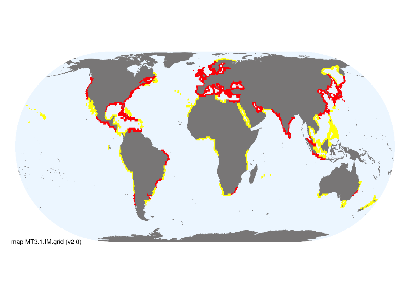
Map description
Marine ecoregions (Spalding et al. 2008) containing major and minor occurrences of urbanized shorelines were identified from the map of night lights (see T7.4), imagery available on Google Earth and expertise of authors. Occurrences were aggregated to 1 degree spatial resolution and intersected with the coastline to exclude areas inland and in the open ocean..
Map code and version: MT3.1.web.map v1.0, available at ![]()
Version history
Profile versions
- v2.1 (2022-04-06): IM Suthers; MJ Bishop; LB Firth; KA Dafforn. DA Keith.1
- v2.01 (2021-12-31): NA.
- v2.0 (2020-06-17): IM Suthers; MJ Bishop; LB Firth; KA Dafforn. DA Keith.
- v1.0 (2020-01-20): RT Kingsford; DA Keith.
Available maps
Read more details about the current map versions here.
- Indicative Map (code: MT3.1.IM.grid, version v2.0)
- Web navigation (code: MT3.1.web.map, version v1.0)

Read more details about older or alternative versions of maps for this functional group.
- Web navigation: discarded (code: MT3.1.web.grid, version v2.0)
- Indicative Map: requires more work (code: MT3.1.IM.orig, version v1.0)
- Indicative Map: discarded (code: MT3.1.IM.grid, version v1.0)
- Web navigation: requires review (code: MT3.1.web.orig, version v1.0)
References
Main references
References used in the different versions of the profiles.
- Dafforn KA, Glasby TM, Airoldi L, Rivero NK, Mayer-Pinto M, Johnston EL (2015) Marine urbanization: an ecological framework for designing multifunctional artificial structures. Frontiers in Ecology and the Environment 13: 82-90. DOI:10.1890/140050
Map references
References used in the different versions of the maps (current and discarded).
- Becker JJ, Sandwell DT, Smith WHF, Braud J, Binder B, Depner J, Fabre D, Factor J, Ingalls S, Kim S-H, Ladner R, Marks K, Nelson S, Pharaoh A, Trimmer R, Von Rosenberg J, Wallace G, Weatherall P (2009) Global Bathymetry and Elevation Data at 30 Arc Seconds Resolution: SRTM30_PLUS, Marine Geodesy 32: 355-371. DOI:10.1080/01490410903297766
- VIIRS Day/Night Band Nighttime Lights, Version 1; Earth Observation Group, NOAA National Centers for Environmental Information (NCEI). Data-set
- Spalding MD, Fox HE, Allen GR, Davidson N, Ferdaña ZA, Finlayson M, Halpern BS, Jorge MA, Lombana A, Lourie SA, Martin KD, McManus E, Molnar J, Recchia CA, Robertson J (2007) Marine ecoregions of the world: a bioregionalization of coastal and shelf areas. Bioscience 57: 573–583. DOI:10.1641/B570707
Footnotes
This is the current version available at official site.↩︎