MT1.3 Sandy Shorelines
MT1. Shorelines biome
MT1
Profile summary
Full profile at https://global-ecosystems.org/explore/groups/MT1.3
Brief description
Beaches, sand bars and spits are exposed to waves and tides on moderate-high energy coasts, and rely on drift seaweed and surf-zone phytoplankton for nutrients. Polychaete worms, bivalve shellfish and a range of smaller invertebrates burrow in the shifting sediments, while larger vertebrate animals like seabirds, egg-laying turtles and scavenging foxes can also be found at various times. Storm tides and waves periodically restructure the sediments and profoundly influence the traits of the organisms living in these highly dynamic systems.
Key features
Intertidal soft-sediment, of large particle-size, lacking conspicuous macrophytes, and dominated by suspension-feeding invertebrates that provide a prey resource for shore birds and fishes.
Overview of distribution
Medium-high energy shorelines, particularly at temperate latitudes.
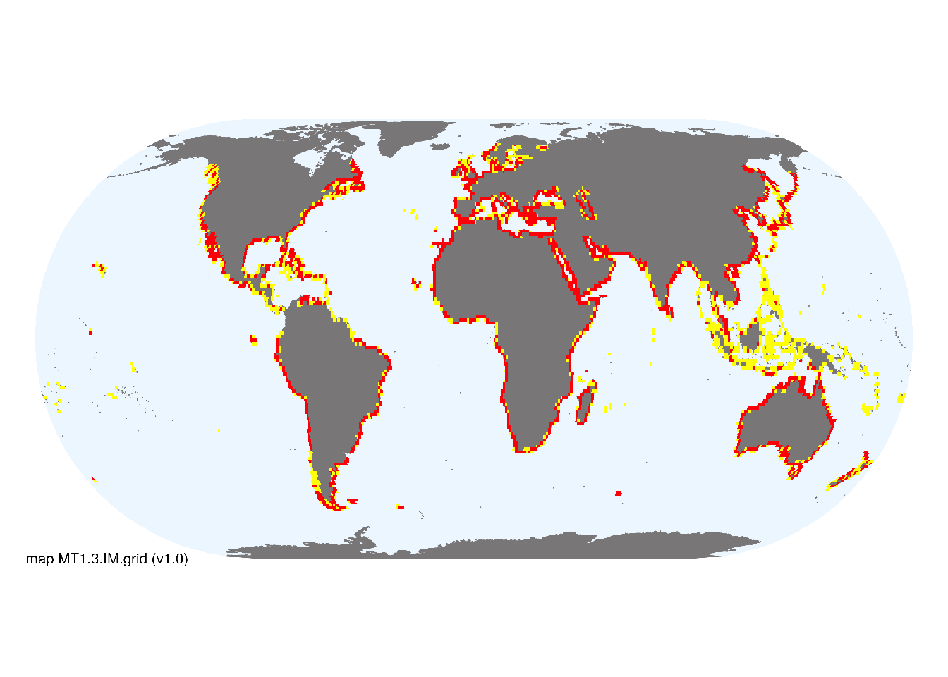
Map description
The indicative map of Sandy shorelines was based on point records of sandy coastlines mapped by Vousdoukas et al. (2020) aggregated to 1 degree spatial resolution. Cells with >50 points were reclassified as major occurrences, and those with 1-50 points were reclassified as minor occurrences. These were clipped to the coastline..
Map code and version: MT1.3.web.map v1.0, available at ![]()
Version history
Profile versions
- v2.1 (2022-04-06): MJ Bishop; SL McSweeney; DA Keith.1
- v2.01 (2021-12-31): NA.
- v2.0 (2020-05-28): MJ Bishop; SL McSweeney; DA Keith.
- v1.0 (2020-01-20): MJ Bishop; NJ Murray; DA Keith.
Available maps
Read more details about the current map versions here.
- Indicative Map (code: MT1.3.IM.grid, version v1.0)
- Web navigation (code: MT1.3.web.map, version v1.0)

Read more details about older or alternative versions of maps for this functional group.
- Indicative Map: discarded (code: MT1.3.IM.orig, version v1.0)
- Web navigation: discarded (code: MT1.3.web.grid, version v1.0)
- Web navigation: requires review (code: MT1.3.web.orig, version v1.0)
- Web navigation: in preparation (code: MT1.3.WM.nwx, version v1.0)
References
Main references
References used in the different versions of the profiles.
- Luijendijk A, Hagenaars G, Ranasinghe R, Baart F, Donchyts G, Aarninkhof S (2018) The State of the World’s Beaches Scientific reports 8(1) 6641 DOI:10.1038/s41598-018-24630-6
- Schlacher TA, Schoeman DS, Dugan J, Lastra M, Jones A, Scapini F, McLachlan A. (2008) Sandy beach ecosystems: key features, sampling issues, management challenges and climate change impacts Marine Ecology 29(S1):70-90 DOI:10.1111/j.1439-0485.2007.00204.x
Map references
References used in the different versions of the maps (current and discarded).
Harris PT, Macmillan-Lawler M, Rupp J, Baker EK (2014) Geomorphology of the oceans. Marine Geology 352: 4-24. 10.1016/j.margeo.2014.01.011
Spalding MD, Fox HE, Allen GR, Davidson N, Ferdaña ZA, Finlayson M, Halpern BS, Jorge MA, Lombana A, Lourie SA, Martin KD, McManus E, Molnar J, Recchia CA, Robertson J (2007) Marine ecoregions of the world: a bioregionalization of coastal and shelf areas. Bioscience 57: 573–583. DOI:10.1641/B570707
Vousdoukas, M., Ranasinghe, R., Mentaschi, L., Plomaritis, T., Athanasiou, P., Luijendijk, A. and Feyen, L. (2020) Sandy coastlines under threat of erosion Nature Climate Change 10, 260–263 DOI:10.1038/s41558-020-0697-0
Footnotes
This is the current version available at official site.↩︎