MFT1.2 Intertidal forests and shrublands
MFT1. Brackish tidal biome
MFT1
Profile summary
Full profile at https://global-ecosystems.org/explore/groups/MFT1.2
Brief description
Mangroves create structurally complex and productive ecosystems in the intertidal zone of depositional coasts, around tropical and warm temperate regions. The biota includes aquatic and terrestrial species, and intertidal specialists. Large volumes of mangrove leaves and twigs are decomposed by fungi and bacteria, mobilising carbon and nutrients for invertebrates such as crabs, worms and snails. Shellfish and juvenile fish are protected from desiccation and predators amongst mangrove roots. Mangrove canopies support many terrestrial species, particularly birds. These forests are important carbon sinks, retaining organic matter in sediments and living biomass.
Key features
Intertidal mangrove-dominated systems, producing high amounts of organic matter that is both buried in situ and exported; sediments dominated by detritivores and leaf shredders, with birds , mammals, reptiles and terrestrial invertebrates occupying the canopy.
Overview of distribution
Tropical and warm temperate coastlines with good sediment supply.
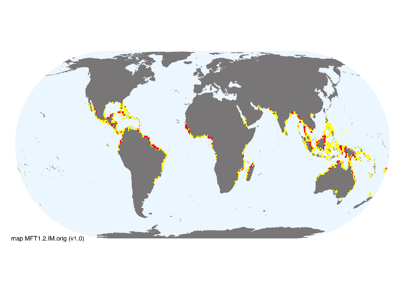
Map description
The indicative map of Intertidal forests and shrublands (MFT1.2) was developed by resampling the known global distribution of mangrove forests for the year 2000 mapped by Giri et al. (2011). We used a buffer of 1km around the distribution data and a 30 arc second grid, thus large aggregations (> 1km2) are depicted as major occurrences, and the buffer areas with small occurrences are shown as minor occurrences. The original high-resolution data is available at UNEP-WCMC..
Map code and version: MFT1.2.web.orig v2.0, available at ![]()
Version history
Profile versions
- v2.1 (2022-04-06): MJ Bishop; AH Altieri; TS Bianchi; DA Keith.1
- v2.01 (2021-12-31): NA.
- v2.0 (2020-05-29): MJ Bishop; AH Altieri; TS Bianchi; DA Keith.
- v1.0 (2020-01-20): MJ Bishop; DA Keith.
Available maps
Read more details about the current map versions here.
- Indicative Map (code: MFT1.2.WM.nwx, version v1.0)
Read more details about older or alternative versions of maps for this functional group.
- Web navigation: testing (code: MFT1.2.web.orig, version v3.0)
- Web navigation: discarded (code: MFT1.2.web.orig, version v2.0)

- Web navigation: discarded (code: MFT1.2.web.orig, version v1.0)
- Indicative Map: discarded (code: MFT1.2.IM.orig, version v1.0)
- Indicative Map: replaced (code: MFT1.2.IM.orig, version v0.2)
References
Main references
References used in the different versions of the profiles.
- Duke N, Ball M, Ellison J (1998) Factors influencing biodiversity and distributional gradients in mangroves Global Ecology & Biogeography Letters 7:27-47 DOI:10.2307/2997695
- Feller IC, Lovelock CE, Berger U,, McKee KL, Joye SB, Ball MC (2010) Biocomplexity in mangrove ecosystems Annual Review of Marine Science 2, 395–417 DOI:10.1146/annurev.marine.010908.163809
- Krauss KW, Lovelock CE, McKee KL, López-Hoffman L, Ewe SM, Sousa WP (2008) Environmental drivers in mangrove establishment and early development: a review Aquatic Botany 89:105-27 DOI:10.1016/j.aquabot.2007.12.014
Map references
References used in the different versions of the maps (current and discarded).
- Bunting P., Rosenqvist A., Lucas R., Rebelo L-M., Hilarides L., Thomas N., Hardy A., Itoh T., Shimada M. and Finlayson C.M. (2018) The Global Mangrove Watch – a New 2010 Global Baseline of Mangrove Extent Remote Sensing 10(10): 1669 DOI:10.3390/rs1010669
- Giri C, Ochieng E, Tieszen LL, Zhu Z, Singh A, Loveland T, Masek J, Duke N (2011) Status and distribution of mangrove forests of the world using earth observation satellite data Global Ecology and Biogeography 20: 154-159 DOI:10.1111/j.1466-8238.2010.00584.x
Footnotes
This is the current version available at official site.↩︎