F3.5 Canals, ditches and drains
F3. Artificial wetlands biome
F3
Profile summary
Full profile at https://global-ecosystems.org/explore/groups/F3.5
Brief description
Canals, ditches and drains are associated with agriculture and cities throughout the world. They take freshwater to and from urban and rural areas, particularly in temperate and subtropical regions. They can carry high nutrient and pollutant loads. Diversity of organisms is generally low, but may be high where there are earthen banks and fringing vegetation. Algae and macrophytes (where present) support microbes and waterbugs and other invertebrates often small fish, amphibians and crustaceans. They are also important pathways for dispersal of some aquatic species.
Key features
Artificial streams often with low horizontal and vertical heterogeneity, but with productivity, diversity and trophic structure highly dependent on fringing vegetation and subsidies of nutrients and carbon from catchments.
Overview of distribution
In urban and irrigation landscapes mostly in temperate and subtropical latitudes.
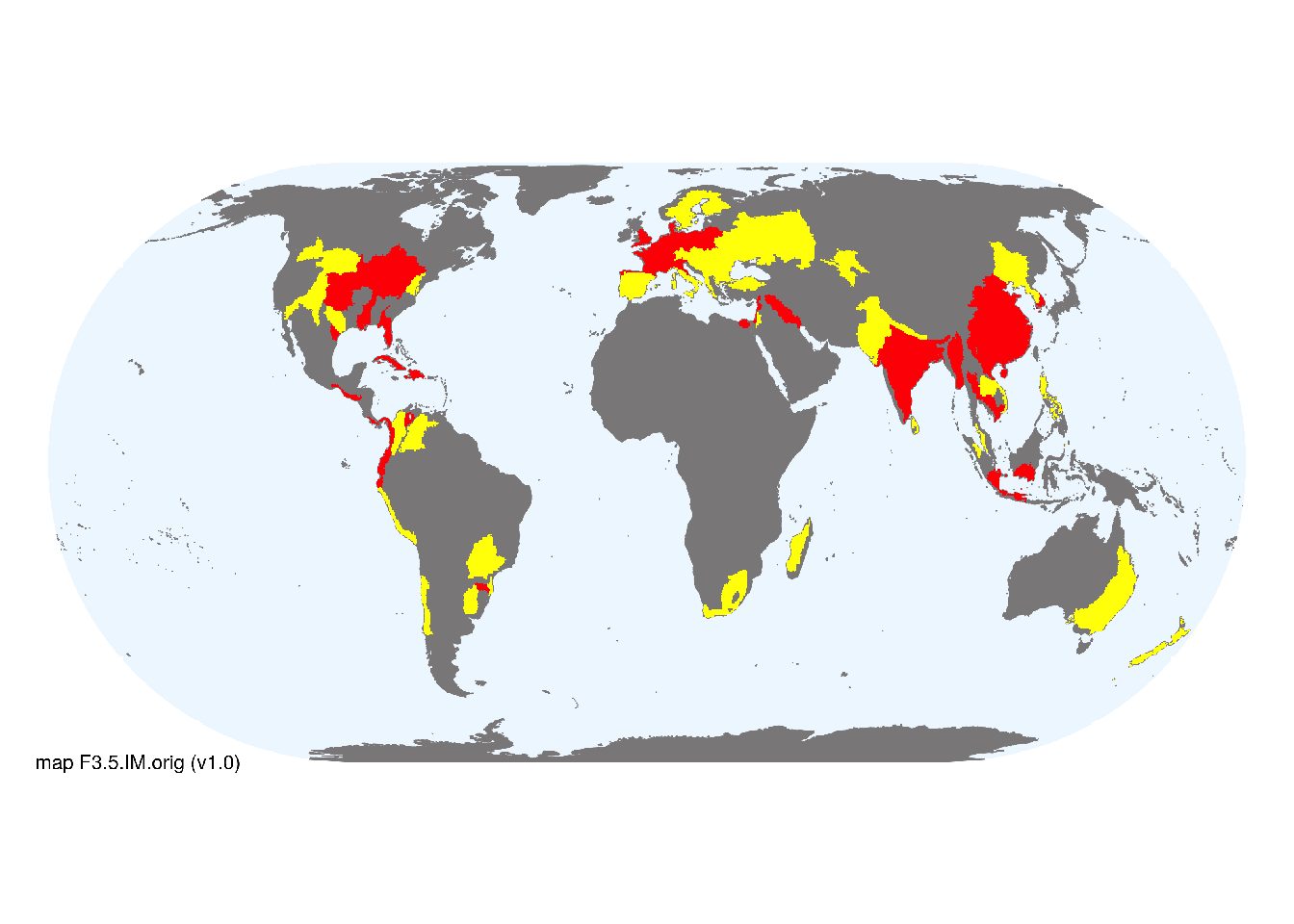
Map description
Freshwater ecoregions (Abell et al. 2008) were identified as containing major or minor occurrences of these functional groups if: i) their descriptions mentioned features consistent with those identifed in the profile of the Ecosystem Functional Group; and ii) if their location was consistent with the ecological drivers described in the profile. The selections were check by expert reviewers. Occurrences were mapped at 30 arc seconds spatial resolution..
Map code and version: F3.5.web.orig v1.0, available at ![]()
Version history
Profile versions
- v2.1 (2022-04-06): RT Kingsford; B Robson; M Kelly-Quinn; DA Keith.1
- v2.01 (2021-12-31): NA.
- v2.0 (2020-06-18): RT Kingsford; B Robson; M Kelly-Quinn; DA Keith.
- v1.0 (2020-01-20): RT Kingsford; DA Keith.
Available maps
Read more details about the current map versions here.
- Indicative Map (code: F3.5.WM.nwx, version v2.0)
Read more details about older or alternative versions of maps for this functional group.
- Indicative Map: requires review (code: F3.5.IM.orig, version v1.0)
- Web navigation: superceeded (code: F3.5.WM.nwx, version v1.0)
- Web navigation: superceeded (code: F3.5.web.orig, version v1.0)

References
Main references
References used in the different versions of the profiles.
- Chester ET, Robson BJ (2013) Anthropogenic refuges for freshwater biodiversity: Their ecological characteristics and management Biological Conservation 166: 64 – 75 DOI:10.1016/j.biocon.2013.06.016
- Nunes AL, Tricarico E, Panov VE, Cardoso AC, Katsanevakis S (2015) Pathways and gateways of freshwater invasions in Europe Aquatic Invasions 10: 359 - 370 DOI:10.3391/ai.2015.10.4.01
- Ricciardi A (2006) Patterns of invasion in the Laurentian Great Lakes in relation to changes in vector activity Diversity and Distributions 12: 425-433 DOI:10.1111/j.1366-9516.2006.00262.x
- Verdonschot RCM, Keizer‐vlek HE, Verdonschot PFM (2011) Biodiversity value of agricultural drainage ditches: a comparative analysis of the aquatic invertebrate fauna of ditches and small lakes Aquatic Conservation: Marine and Freshwater Ecosystems 21, 715-727 DOI:10.1002/aqc.1220
Map references
References used in the different versions of the maps (current and discarded).
- Abell R, Thieme ML, Revenga C, Bryer M, Kottelat M, Bogutskaya N, Coad B, Mandrak N, Contreras Balderas S, Bussing W, Stiassny MLJ, Skelton P, Allen GR, Unmack P, Naseka A, Ng R, Sindorf N, Robertson J, Armijo E, Higgins JV, Heibel TJ, Wikramanayake E, Olson D, López HL, Reis RE, Lundberg JG, Sabaj Pérez MH, Petry P (2008) Freshwater ecoregions of the world: A new map of biogeographic units for freshwater biodiversity conservation, BioScience 58: 403–414. DOI:10.1641/B580507
- Deepak Nagaraj, Eleanor Proust, Alberto Todeschini, Maria Cristina Rulli, Paolo D’Odorico (2021) A new dataset of global irrigation areas from 2001 to 2015 Advances in Water Resources 152: 103910 DOI:j.advwatres.2021.103910
- Karra, Kontgis, et al. (2021) Global land use/land cover with Sentinel-2 and deep learning IGARSS 2021-2021 IEEE International Geoscience and Remote Sensing Symposium IEEE
Footnotes
This is the current version available at official site.↩︎