F3.4 Freshwater aquafarms
F3. Artificial wetlands biome
F3
Profile summary
Full profile at https://global-ecosystems.org/explore/groups/F3.4
Brief description
Freshwater aquafarms are ponds constructed from earthworks or cages built within freshwater lakes, rivers and reservoirs. They are most common in Asia. and used to produce species. Their commercial production of fish and crustacean involves intensive interventions, including focussed inputs of food and nutrients, and control of competitors, predators and diseases that may limit production of target species. Consequently habitat diversity and primary production are low, and non-target biota is limited to opportunistic colonisers from adjacent water sources, including insects, fish, frogs, waterbirds and some aquatic plants.
Key features
Artificial mostly permanent waterbodies managed for production of fish or crustaceans with managed inputs of nutrients and energy Simple trophic networks of opportunistic colonists supported mainly be algal productivity.
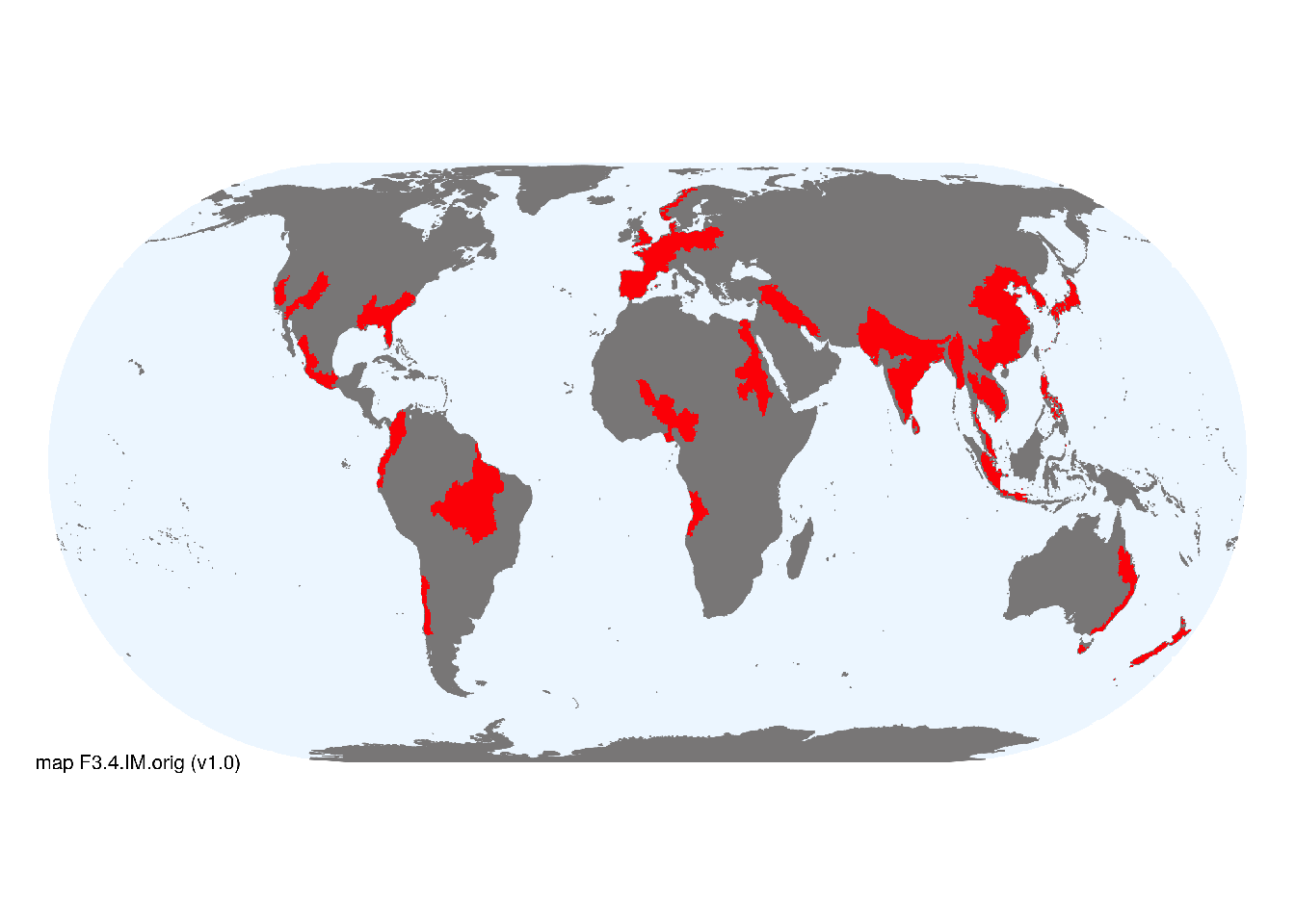
Overview of distribution
Mostly in Asia but also in northern and western Europe, North and West Africa, the Americas, and southeast Australia and New Zealand.
Map description
Freshwater ecoregions (Abell et al. 2008) were identified as containing major or minor occurrences of these functional groups if: i) their descriptions mentioned features consistent with those identifed in the profile of the Ecosystem Functional Group; and ii) if their location was consistent with the ecological drivers described in the profile. The selections were check by expert reviewers. Occurrences were mapped at 30 arc seconds spatial resolution..
Map code and version: F3.4.web.orig v1.0, available at ![]()
Version history
Profile versions
- v2.1 (2022-04-06): RT Kingsford; M Beveridge; DA Keith.1
- v2.01 (2021-12-31): NA.
- v2.0 (2020-05-26): RT Kingsford; M Beveridge; DA Keith.
- v1.0 (2020-01-20): RT Kingsford; DA Keith.
Available maps
Read more details about the current map versions here.
- Web navigation (code: F3.4.web.orig, version v1.0)

- Indicative Map (code: F3.4.IM.orig, version v1.0)
Read more details about older or alternative versions of maps for this functional group.
References
Main references
References used in the different versions of the profiles.
- Ottinger M, Clauss K, Kuenzer CJO (2016) Aquaculture: relevance, distribution, impacts and spatial assessments–a review Ocean & Coastal Management 119: 244-266 DOI:10.1016/j.ocecoaman.2015.10.015
Map references
References used in the different versions of the maps (current and discarded).
- Abell R, Thieme ML, Revenga C, Bryer M, Kottelat M, Bogutskaya N, Coad B, Mandrak N, Contreras Balderas S, Bussing W, Stiassny MLJ, Skelton P, Allen GR, Unmack P, Naseka A, Ng R, Sindorf N, Robertson J, Armijo E, Higgins JV, Heibel TJ, Wikramanayake E, Olson D, López HL, Reis RE, Lundberg JG, Sabaj Pérez MH, Petry P (2008) Freshwater ecoregions of the world: A new map of biogeographic units for freshwater biodiversity conservation, BioScience 58: 403–414. DOI:10.1641/B580507
Footnotes
This is the current version available at official site.↩︎