F3.3 Rice paddies
F3. Artificial wetlands biome
F3
Profile summary
Full profile at https://global-ecosystems.org/explore/groups/F3.3
Brief description
Rice paddies cover more than a million square kilometres mostly in tropical to warm temperate climates, especially Southeast Asia. They are filled by rainfall or river water diversions. Their levees and channels retain shallow water areas, with nutrients inputs from inflows and fertilisers. Planting and harvest establishes a regular cycle of disturbance, with many paddies also supporting production of fish and crustaceans, Their simple foodwebs are adapted to temporary flooding and the harvest cycle, including algae and plankton, waterbugs, frogs and waterbirds.
Key features
Artificial wetlands with limited horizontal and vertical heterogeneity, filled seasonally with water from rivers or rainfall and frequently disturbed by planting and harvest of rice. Simple trophic networks with colonists from rivers and wetlands that may also include managed fish populations.
Overview of distribution
Mostly in tropical and subtropical southeastand south Asia, also in Africa, Europe, South America, North America and southeast Australia.
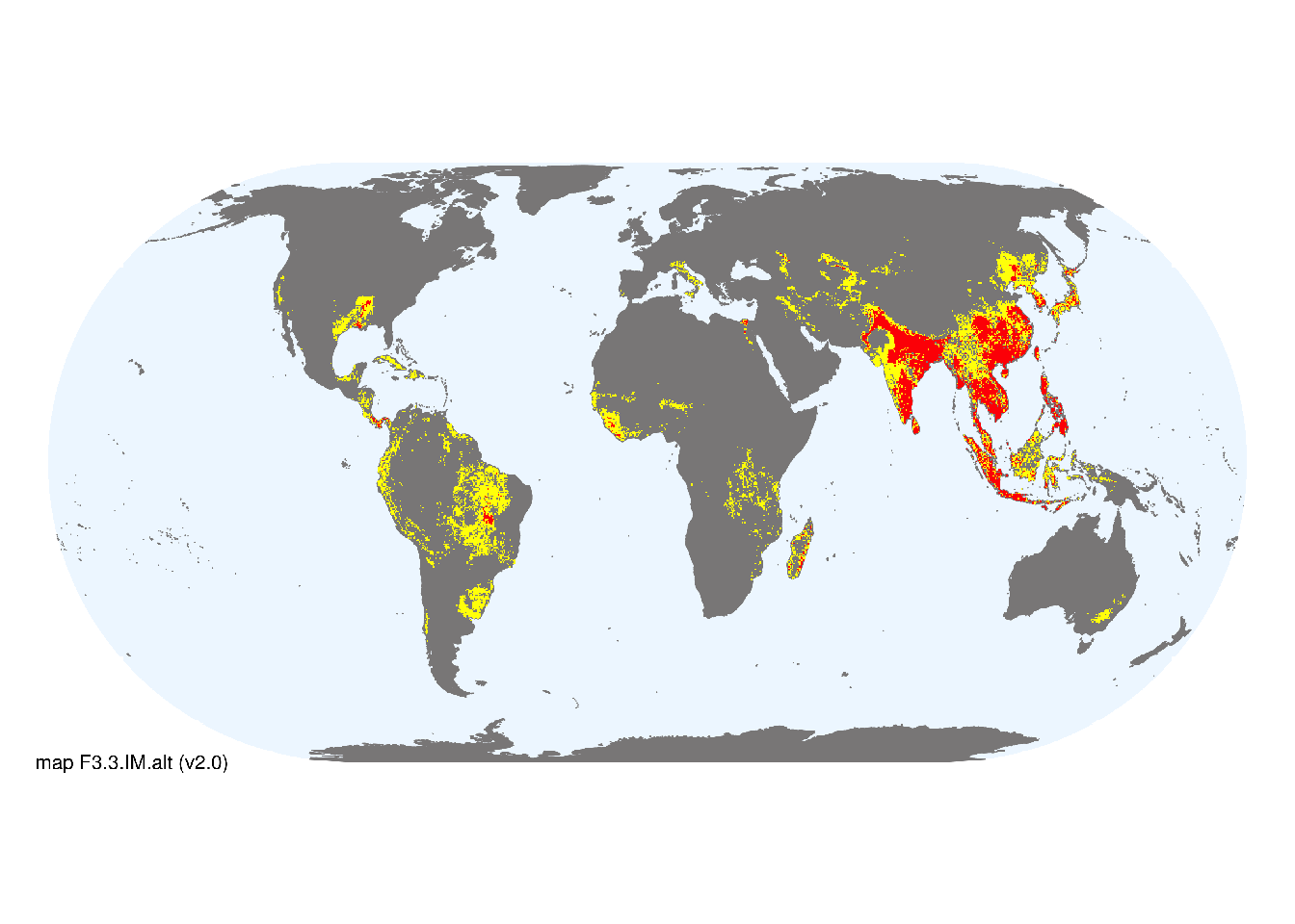
Map description
The distribution of rice paddies was estimated from the percentage of rice cover at a 5 arc minute resolution based on Monfreda et al. (2008). Cells with > 10% rice cover were designated as major occurrences, and those with 1-10% rice cover were designated as minor occurrences..
Map code and version: F3.3.web.alt v2.0, available at ![]()
Version history
Profile versions
- v2.1 (2022-04-06): RT Kingsford; DA Keith.1
- v2.01 (2021-12-31): NA.
- v2.0 (2020-06-18): RT Kingsford; DA Keith.
- v1.0 (2020-01-20): RT Kingsford; DA Keith.
Available maps
Read more details about the current map versions here.
- Web navigation (code: F3.3.web.alt, version v2.0)

- Indicative Map (code: F3.3.IM.alt, version v2.0)
Read more details about older or alternative versions of maps for this functional group.
- Indicative Map: discarded (code: F3.3.IM.orig, version v1.0)
- Indicative Map: discarded (code: F3.3.IM.alt, version v1.0)
- Web navigation: requires review (code: F3.3.web.orig, version v1.0)
- Web navigation: in preparation (code: F3.3.WM.nwx, version v1.0)
References
Main references
References used in the different versions of the profiles.
- Fernando CJH (1993) Rice field ecology and fish culture—an overview Hydrobiologia 259: 91-113
- Liesack W, Schnell S, Revsbech NP (2000) Microbiology of flooded rice paddies FEMS Microbiology Reviews 24: 625-645 DOI:10.1111/j.1574-6976.2000.tb00563.x
Map references
References used in the different versions of the maps (current and discarded).
- Monfreda CN, Ramankutty N, Foley JA (2008) Farming the planet: 2. Geographic distribution of crop areas, yields, physiological types, and net primary production in the year 2000 Global Biogeochemical Cycles 22: GB1022
Footnotes
This is the current version available at official site.↩︎