F2.5 Ephemeral freshwater lakes
F2. Lakes biome
F2
Profile summary
Full profile at https://global-ecosystems.org/explore/groups/F2.5
Brief description
These are shallow lakes that are mostly dry, and then fill for weeks or months, before drying again. During dry periods, many animals or plants survive as eggs, seeds or other dormant forms, while other species disperse. Floods, bring water from surrounding catchments and floodplains with organic matter, nutrients and fine sediments, and trigger movement of birds and mammals. Floods activate simple foodwebs, comprising abundant algae, zooplankton, waterbugs and crustaceans, which have rapid life-cycles able to exploit windows of productivity. This produces food for frogs and visiting waterbirds.
Key features
Shallow temporary lakes, depressions or pans with long dry periods of low productivity, punctuated by episodes of inflow that bring large resource subsidies from catchments, resulting in high productivity, population turnover and trophic connectivity.
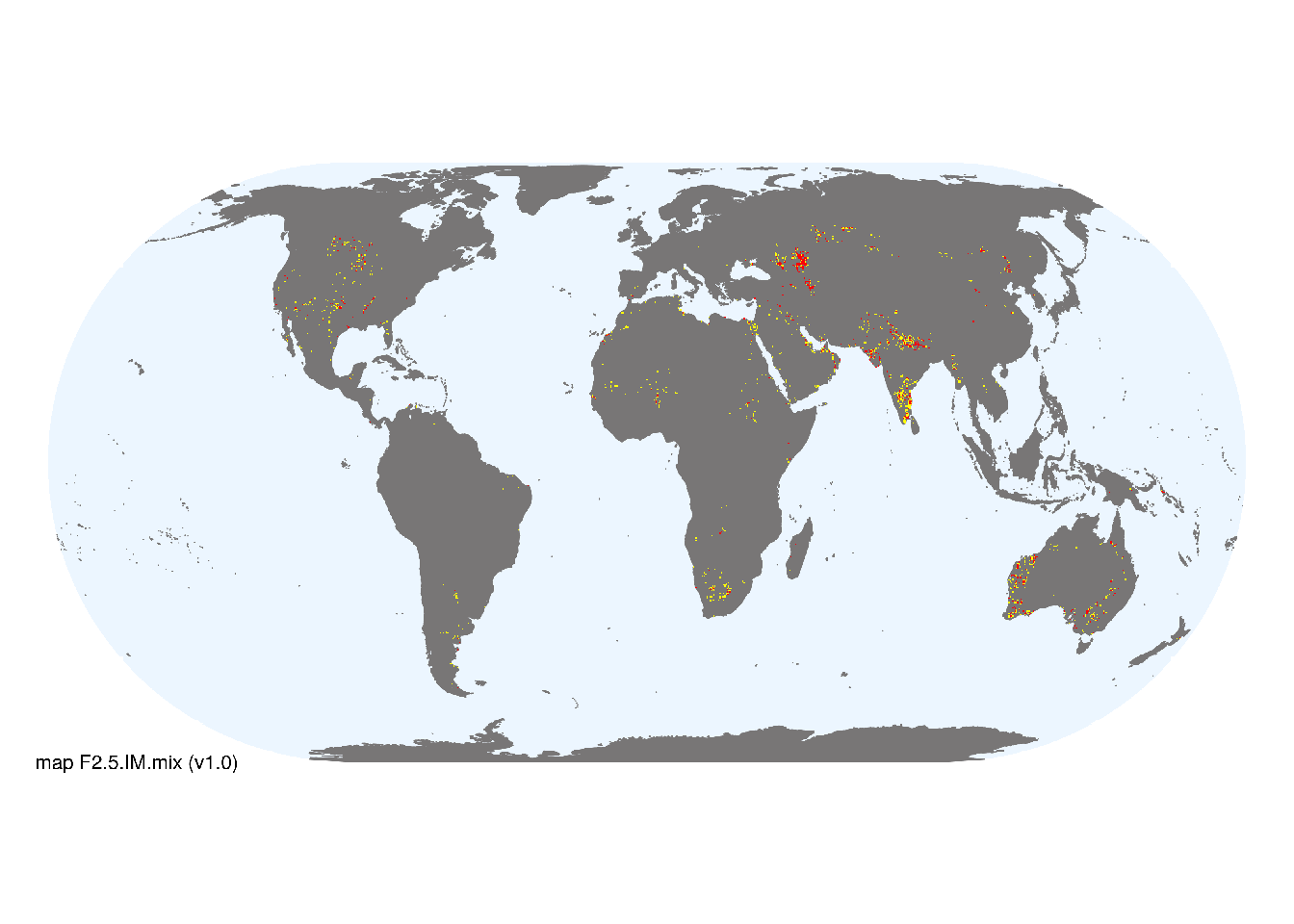
Overview of distribution
Semi-arid and arid regions at mid latitudes of Africa, southern Australia, Eurasia, Europe and western parts of North and South America.
Map description
Location of natural ephemeral freshwater lakes was taken from global lake databases (Lehner and Döll 2004; types 1 an 3 from Messager et al. 2016), excluding those from endorheic basins cf. F2.7 (Linke et al. 2019), and intersected with estimates of ephemeral surface water (classes 9 and 10 from Pekel et al. 2016). Occurrences were aggregated to 10 minutes spatial resolution..
Map code and version: F2.5.web.mix v1.0, available at ![]()
Version history
Profile versions
- v2.1 (2022-04-06): DJ Roux; R Mac Nally; RT Kingsford; JT Hollibaugh; DA Keith.1
- v2.01 (2021-12-31): NA.
- v2.0 (2020-06-24): DJ Roux; R Mac Nally; RT Kingsford; JT Hollibaugh; DA Keith.
- v1.0 (2020-01-20): DJ Roux; RC Mac Nally; RT Kingsford; DA Keith.
Available maps
Read more details about the current map versions here.
- Web navigation (code: F2.5.web.mix, version v1.0)

- Indicative Map (code: F2.5.IM.mix, version v1.0)
Read more details about older or alternative versions of maps for this functional group.
- Indicative Map: discarded (code: F2.5.IM.alt, version v2.0)
- Indicative Map: discarded (code: F2.5.IM.orig, version v1.0)
- Web navigation: duplicated (code: F2.5.web.map, version v1.0)
- Web navigation: requires review (code: F2.5.web.orig, version v1.0)
References
Main references
References used in the different versions of the profiles.
- Hancock MA, Timms BV (2002) Ecology of four turbid clay pans during a filling-drying cycle in the Paroo, semi-arid Australia Hydrobiologia 479: 95-107
- Meintjes S (1996) Seasonal changes in the invertebrate community of small shallow ephemeral pans at Bain’s Vlei, South Africa Hydrobiologia 317: 51-64
- Williams WD (2000) Biodiversity in temporary wetlands of dryland regions Internationale Vereinigung für theoretische und angewandte Limnologie: Verhandlungen 27: 141-144
Map references
References used in the different versions of the maps (current and discarded).
- Abell R, Thieme ML, Revenga C, Bryer M, Kottelat M, Bogutskaya N, Coad B, Mandrak N, Contreras Balderas S, Bussing W, Stiassny MLJ, Skelton P, Allen GR, Unmack P, Naseka A, Ng R, Sindorf N, Robertson J, Armijo E, Higgins JV, Heibel TJ, Wikramanayake E, Olson D, López HL, Reis RE, Lundberg JG, Sabaj Pérez MH, Petry P (2008) Freshwater ecoregions of the world: A new map of biogeographic units for freshwater biodiversity conservation, BioScience 58: 403–414. DOI:10.1641/B580507
- Beck, H., Zimmermann, N., McVicar, T. et al. (2018) Present and future Köppen-Geiger climate classification maps at 1-km resolution Sci Data 5, 180214 DOI:10.1038/sdata.2018.214
- Lehner, B. and Döll, P. (2004): Development and validation of a global database of lakes, reservoirs and wetlands. Journal of Hydrology 296/1-4: 1-22. Data-set
- Linke, S., Lehner, B., Ouellet Dallaire, C., Ariwi, J., Grill, G., Anand, M., Beames, P., Burchard-Levine, V., Maxwell, S., Moidu, H., Tan, F., Thieme, M. (2019) Global hydro-environmental sub-basin and river reach characteristics at high spatial resolution Scientific Data 6: 283 DOI:10.1038/s41597-019-0300-6
- Messager, M.L., Lehner, B., Grill, G., Nedeva, I., Schmitt, O. (2016) Estimating the volume and age of water stored in global lakes using a geo-statistical approach Nature Communications 13603 DOI:10.1038/ncomms13603
- Pekel JF, Cottam A, Gorelick N, Belward AS (2016) High-resolution mapping of global surface water and its long-term changes Nature 540, 418-422 DOI:10.1038/nature20584
Footnotes
This is the current version available at official site.↩︎