F1.6 Episodic arid rivers
F1. Rivers and streams biome
F1
Profile summary
Full profile at https://global-ecosystems.org/explore/groups/F1.6
Brief description
These desert rivers occur mostly in flat areas of arid and semi-arid mid-latitudes. Channels are typically broad, flat, and often branching, with soft sandy sediments. They are dry most of the time, but punctuated by high-volume, short duration flows that transport nutrients and stimulate high productivity by algae and zooplankton. Plants and animals can either tolerate or avoid long, dry periods and then exploit short pulses of abundant resources, producing hotspots of biodiversity and ecological activity in arid landscapes.
Key features
Rivers with high temporal flow variability which determines periods of high and low productivity, supporting high levels of biodiversity and complex trophic networks during floods and simple trophic networks during dry periods.
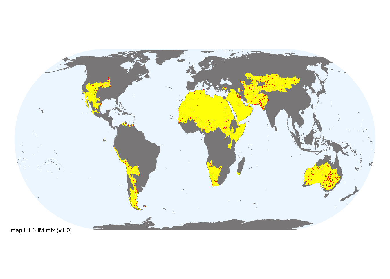
Overview of distribution
Arid and semi-arid landscapes in mid-latitudes mostly in lowlands.
Map description
Freshwater ecoregions (Abell et al. 2008) were identified as containing occurrences of these functional groups if: i) their descriptions mentioned features consistent with those identified in the profile of the Ecosystem Functional Group; and ii) if their location was consistent with the ecological drivers described in the profile. Within the selected ecoregions, remote sensing estimates of ephemeral surface water (classes 4, 5 and 8 from Pekel et al. 2016) were used to identify major occurrences. The remaining areas of selected ecoregions were mapped as minor occurrences..
Map code and version: F1.6.web.mix v1.0, available at ![]()
Version history
Profile versions
- v2.1 (2022-04-06): JL Nel; RT Kingsford; R Mac Nally; PS Giller; B Robson; AH Arthington; DA Keith.1
- v2.01 (2021-12-31): NA.
- v2.0 (2020-05-24): JL Nel; RT Kingsford; R Mac Nally; PS Giller; B Robson; AH Arthington; DA Keith.
- v1.0 (2020-01-20): JL Nel; RT Kingsford; RC Mac Nally; DA Keith.
Available maps
Read more details about the current map versions here.
- Indicative Map (code: F1.6.IM.mix, version v2.0)
- Web navigation (code: F1.6.web.mix, version v1.0)

Read more details about older or alternative versions of maps for this functional group.
- Indicative Map: discarded (code: F1.6.IM.alt, version v2.0)
- Web navigation: in preparation (code: F1.6.WM.nwx, version v1.0)
- Web navigation: requires review (code: F1.6.web.orig, version v1.0)
- Indicative Map: superceeded (code: F1.6.IM.mix, version v1.0)
- Indicative Map: discarded (code: F1.6.IM.orig, version v1.0)
References
Main references
References used in the different versions of the profiles.
- Kingsford RT (2006) Ecology of desert rivers Cambridge University Press, Cambridge. ISBN 13 978-0-521-81825-4
- Sheldon et al. (2010) Ecological roles and threats to aquatic refuges in arid landscapes: dryland river waterholes Marine & Freshwater Research 61, 885-895
Map references
References used in the different versions of the maps (current and discarded).
- Abell R, Thieme ML, Revenga C, Bryer M, Kottelat M, Bogutskaya N, Coad B, Mandrak N, Contreras Balderas S, Bussing W, Stiassny MLJ, Skelton P, Allen GR, Unmack P, Naseka A, Ng R, Sindorf N, Robertson J, Armijo E, Higgins JV, Heibel TJ, Wikramanayake E, Olson D, López HL, Reis RE, Lundberg JG, Sabaj Pérez MH, Petry P (2008) Freshwater ecoregions of the world: A new map of biogeographic units for freshwater biodiversity conservation, BioScience 58: 403–414. DOI:10.1641/B580507
- Messager, M. L., Lehner, B., Cockburn, C., Lamouroux, N., Pella, H., Snelder, T., Tockner, K., Trautmann, T., Watt, C. & Datry, T. (2021) Global prevalence of non-perennial rivers and streams Nature DOI:10.1038/s41586-021-03565-5
- Ouellet Dallaire, C., Lehner, B., Sayre, R., Thieme, M. (2018): A multidisciplinary framework to derive global river reach classifications at high spatial resolution. Environmental Research Letters 14: 024003. DOI: 10.1088/1748-9326/aad8e9
- Pekel JF, Cottam A, Gorelick N, Belward AS (2016) High-resolution mapping of global surface water and its long-term changes Nature 540, 418-422 DOI:10.1038/nature20584
- Yamazaki D., D. Ikeshima, J. Sosa, P.D. Bates, G.H. Allen, T.M. Pavelsky (2019) MERIT Hydro: A high-resolution global hydrography map based on latest topography datasets Water Resources Research vol.55, pp.5053-5073 DOI:10.1029/2019WR024873
Footnotes
This is the current version available at official site.↩︎