F1.5 Seasonal lowland rivers
F1. Rivers and streams biome
F1
Profile summary
Full profile at https://global-ecosystems.org/explore/groups/F1.5
Brief description
These medium to large rivers in tropical, subtropical and temperate lowlands have markedly seasonal flows due to seasonal water supply in the catchments. Their single or multi-channelled forms link to floodplain wetlands, and transport large floods during wet seasons: summer in the tropics or winter-spring in temperate latitudes. Productivity is high, both within channels and on connected floodplains, with algae and aquatic plants supporting complex food webs, and providing seasonal nurseries for breeding animals.
Key features
Highly productive large rivers with seasonal hydrology large floodplain subsidies. Short food chains support large mobile predaors.
Overview of distribution
Tropical, subtropical and temperate lowlands.
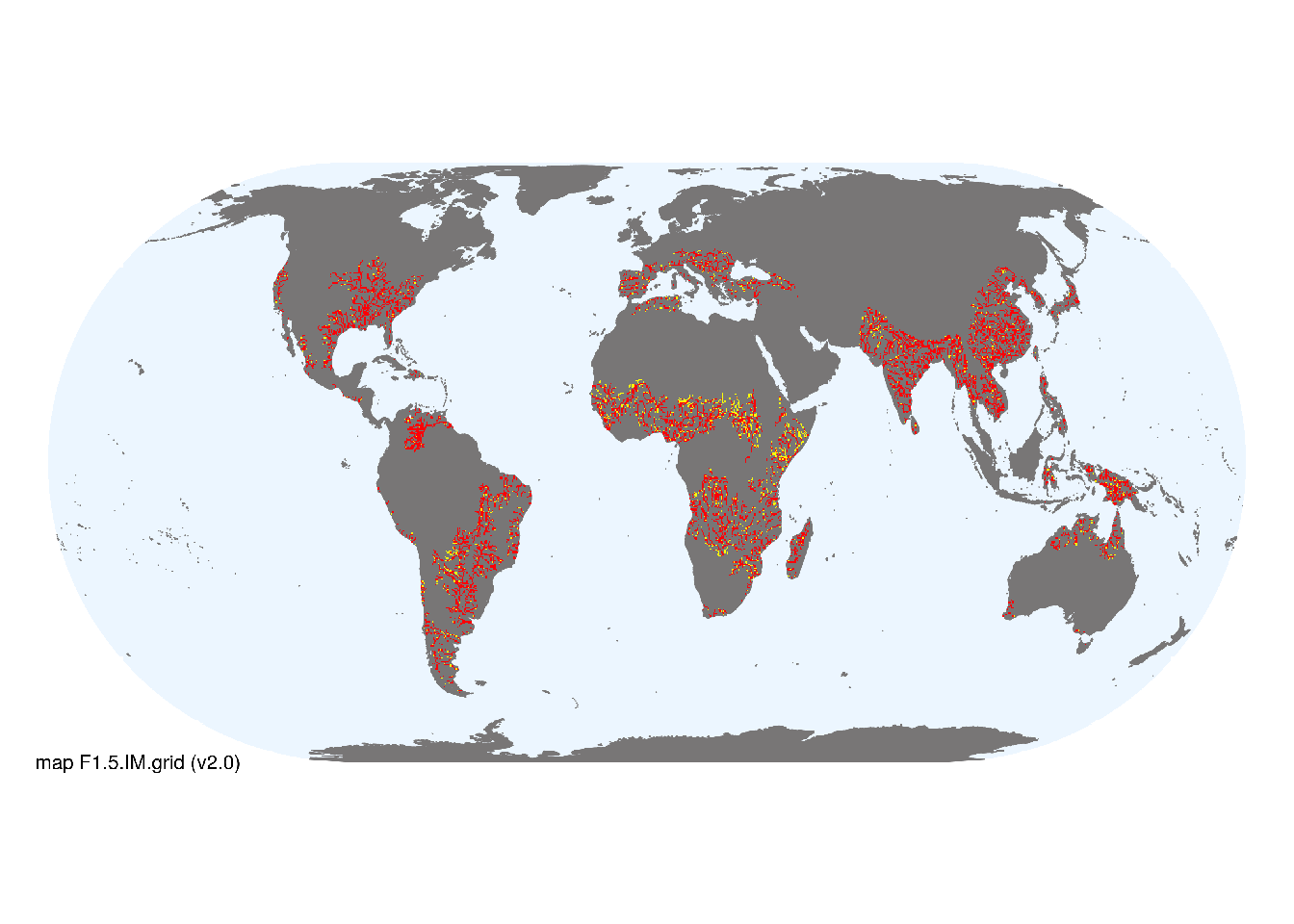
Map description
Freshwater ecoregions (Abell et al. 2008) were identified as containing occurrences of these functional groups if: i) their descriptions mentioned features consistent with those identified in the profile of the Ecosystem Functional Group; and ii) if their location was consistent with the ecological drivers described in the profile. Within these areas, major occurrences were mapped using stream orders 4-9 taken from the RiverATLAS (v1.0) database (Linke et al.2019) combined with global estimates of surface water phenology (classes 1, 2 and 7 from Pekel et al. 2016). The remaining area of selected ecoregions was designated as minor occurrences..
Map code and version: F1.5.web.map v1.0, available at ![]()
Version history
Profile versions
- v2.1 (2022-04-06): RT Kingsford; B Robson; PS Giller; AH Arthington; DA Keith.1
- v2.01 (2021-12-31): NA.
- v2.0 (2020-05-24): RT Kingsford; B Robson; PS Giller; AH Arthington; DA Keith.
- v1.0 (2020-01-20): RT Kingsford; DA Keith.
Available maps
Read more details about the current map versions here.
- Indicative Map (code: F1.5.IM.grid, version v2.0)
- Web navigation (code: F1.5.web.map, version v1.0)

Read more details about older or alternative versions of maps for this functional group.
- Indicative Map: discarded (code: F1.5.IM.orig, version v2.0)
- Indicative Map: discarded (code: F1.5.IM.alt, version v2.0)
- Web navigation: duplicated (code: F1.5.web.grid, version v2.0)
- Web navigation: requires review (code: F1.5.web.orig, version v1.0)
- Indicative Map: replaced (code: F1.5.IM.orig, version v1.0)
- Web navigation: in preparation (code: F1.5.WM.nwx, version v1.0)
- Indicative Map: discarded (code: F1.5.IM.grid, version v1.0)
- Indicative Map: discarded (code: F1.5.IM.mix, version v1.0)
References
Main references
References used in the different versions of the profiles.
- Datry T, Bonada N, Boulton A (2017) Intermittent rivers and ephemeral streams: ecology and management (Academic Press: Burlington)
- Douglas MM, Bunn SE, Davies PM (2005) River and wetland food webs in Australia’s wet-dry tropics: general principles and implications for management Marine and Freshwater Research 56: 329-342 DOI:10.1071/mf04084
- Layman CA, Winemiller KO, Arrington DA, Jepsen DB (2005) Body size and trophic position in a diverse tropical food web Ecology 86:2530-2535 DOI:10.1890/04-1098
Map references
References used in the different versions of the maps (current and discarded).
- Abell R, Thieme ML, Revenga C, Bryer M, Kottelat M, Bogutskaya N, Coad B, Mandrak N, Contreras Balderas S, Bussing W, Stiassny MLJ, Skelton P, Allen GR, Unmack P, Naseka A, Ng R, Sindorf N, Robertson J, Armijo E, Higgins JV, Heibel TJ, Wikramanayake E, Olson D, López HL, Reis RE, Lundberg JG, Sabaj Pérez MH, Petry P (2008) Freshwater ecoregions of the world: A new map of biogeographic units for freshwater biodiversity conservation, BioScience 58: 403–414. DOI:10.1641/B580507
- Linke, S., Lehner, B., Ouellet Dallaire, C., Ariwi, J., Grill, G., Anand, M., Beames, P., Burchard-Levine, V., Maxwell, S., Moidu, H., Tan, F., Thieme, M. (2019) Global hydro-environmental sub-basin and river reach characteristics at high spatial resolution Scientific Data 6: 283 DOI:10.1038/s41597-019-0300-6
- Messager, M. L., Lehner, B., Cockburn, C., Lamouroux, N., Pella, H., Snelder, T., Tockner, K., Trautmann, T., Watt, C. & Datry, T. (2021) Global prevalence of non-perennial rivers and streams Nature DOI:10.1038/s41586-021-03565-5
- Ouellet Dallaire, C., Lehner, B., Sayre, R., Thieme, M. (2018): A multidisciplinary framework to derive global river reach classifications at high spatial resolution. Environmental Research Letters 14: 024003. DOI: 10.1088/1748-9326/aad8e9
- Pekel JF, Cottam A, Gorelick N, Belward AS (2016) High-resolution mapping of global surface water and its long-term changes Nature 540, 418-422 DOI:10.1038/nature20584
Footnotes
This is the current version available at official site.↩︎