F1.3 Freeze-thaw rivers and streams
F1. Rivers and streams biome
F1
Profile summary
Full profile at https://global-ecosystems.org/explore/groups/F1.3
Brief description
In cold climates at high latitudes or altitudes, the surfaces of both small streams and large rivers freeze in winter. In winter, the layer of surface ice reduces nutrient inputs and light penetration, limiting the productivity of these ecosystems and the diversity of their biota. In spring, meltwaters transport increased organic matter and nutrients, producing seasonal peaks in abundance of algae and phytoplankton. Animals, such as fish and beavers, tolerate near-freezing water temperatures, while a range of invertebrates and other vertebrates come to forage from spring to autumn.
Key features
Cold-climate streams with seasonally frozen surface water and variable melt flows and aquatic biota with cold-resistance and/or seasonal dormancy.
Overview of distribution
High latitudes and/or high mountains, especially boreal regions.
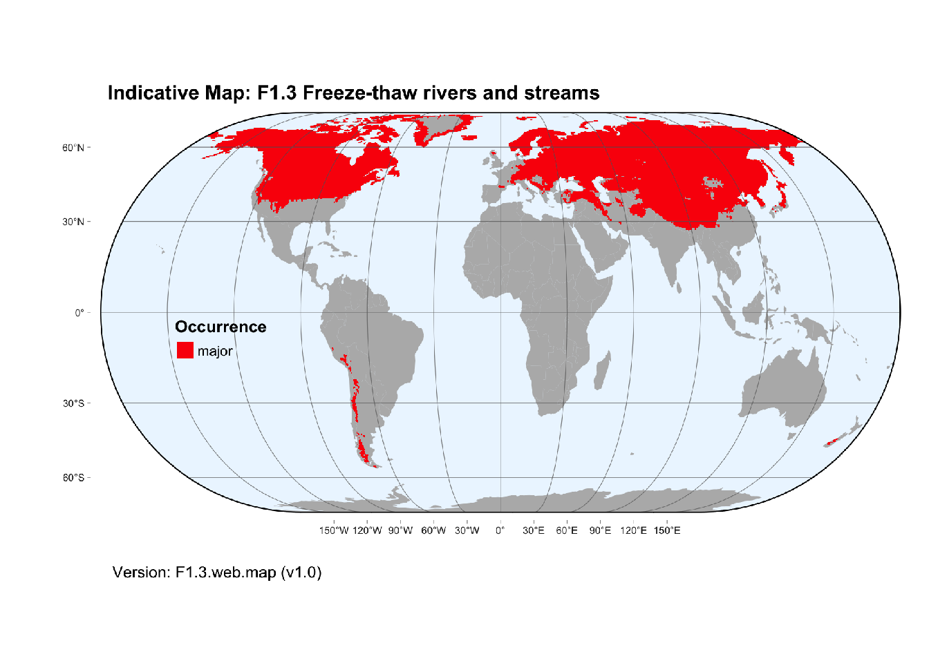
Map description
The distribution of freeze-thaw rivers and streams was mapped from the Global River Classification database (Ouellet Dallaire et al. 2018), including all reaches with with minimum temperature below 0°C..
Map code and version: F1.3.web.map v1.0, available at ![]()
Version history
Profile versions
- v2.1 (2022-04-06): RT Kingsford; PS Giller; DA Keith.1
- v2.01 (2021-12-31): NA.
- v2.0 (2020-06-24): RT Kingsford; PS Giller; DA Keith.
- v1.0 (2020-01-20): RT Kingsford; DA Keith.
Available maps
Read more details about the current map versions here.
- Indicative Map (code: F1.3.IM.grid, version v1.0)
- Web navigation (code: F1.3.web.map, version v1.0)

Read more details about older or alternative versions of maps for this functional group.
- Indicative Map: discarded (code: F1.3.IM.alt, version v2.0)
- Web navigation: discarded (code: F1.3.web.grid, version v1.0)
- Indicative Map: discarded (code: F1.3.IM.mix, version v1.0)
- Web navigation: requires review (code: F1.3.web.mix, version v1.0)
- Web navigation: requires review (code: F1.3.web.orig, version v1.0)
- Indicative Map: discarded (code: F1.3.IM.orig, version v1.0)
- Web navigation: in preparation (code: F1.3.WM.nwx, version v1.0)
References
Main references
References used in the different versions of the profiles.
- Guo LD, Cai YH, Belzile C, Macdonald RW (2012) Sources and export fluxes of inorganic and organic carbon and nutrient species from the seasonally ice-covered Yukon River Biogeochemistry 107: 187-206 DOI:10.1007/s10533-010-9545-z
- Olsson TI (1981) Overwintering of benthic macroinvertebrates in ice and frozen sediment in a North Swedish river Ecography 4: 161-166 DOI:10.1111/j.1600-0587.1981.tb00993.x
Map references
References used in the different versions of the maps (current and discarded).
- Abell R, Thieme ML, Revenga C, Bryer M, Kottelat M, Bogutskaya N, Coad B, Mandrak N, Contreras Balderas S, Bussing W, Stiassny MLJ, Skelton P, Allen GR, Unmack P, Naseka A, Ng R, Sindorf N, Robertson J, Armijo E, Higgins JV, Heibel TJ, Wikramanayake E, Olson D, López HL, Reis RE, Lundberg JG, Sabaj Pérez MH, Petry P (2008) Freshwater ecoregions of the world: A new map of biogeographic units for freshwater biodiversity conservation, BioScience 58: 403–414. DOI:10.1641/B580507
- Ouellet Dallaire, C., Lehner, B., Sayre, R., Thieme, M. (2018): A multidisciplinary framework to derive global river reach classifications at high spatial resolution. Environmental Research Letters 14: 024003. DOI: 10.1088/1748-9326/aad8e9
- Yang, X., Pavelsky, T.M. and Allen, G.H. The past and future of global river ice. Nature 577, 69–73 (2020). DOI: 10.1038/s41586-019-1848-1
Footnotes
This is the current version available at official site.↩︎