F1.2 Permanent lowland rivers
F1. Rivers and streams biome
F1
Profile summary
Full profile at https://global-ecosystems.org/explore/groups/F1.2
Brief description
Lowland rivers with slow continuous flows up to 10,000m3/s are common at low elevations throughout tropical and temperate parts of the world. These are productive ecosystems with major energy and fine sediment inputs from floodplains and upper catchments. Zooplankton can be abundant, along with aquatic plants and diverse communities of fish able to tolerate a range of temperatures and oxygen concentrations, as well as reptiles, birds, and mammals that depend wholly or partly on lowland lotic aquatic habitats.
Key features
Low-medium velocity, high volume, perennial flows with abundant zooplankton, fish, macrophytes, macroinvertebrates & piscivores.
Overview of distribution
Global lowlands fed by wet uplands.
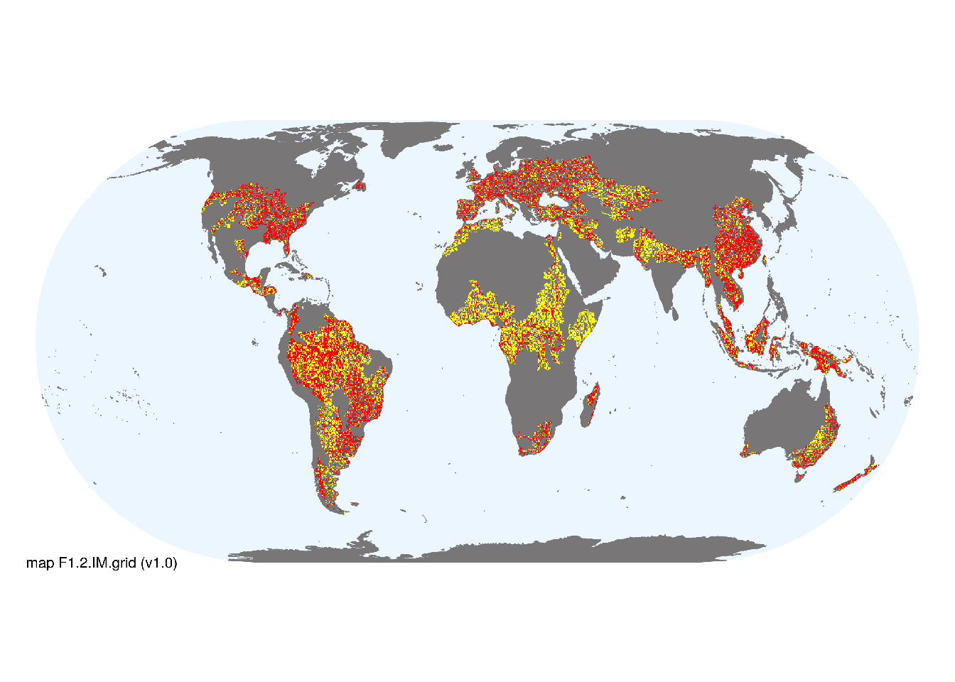
Map description
Freshwater ecoregions (Abell et al. 2008) were identified as containing occurrences of these functional groups if: i) their descriptions mentioned features consistent with those identified in the profile of the Ecosystem Functional Group; and ii) if their location was consistent with the ecological drivers described in the profile. Within these areas, major occurrences were mapped using stream orders 4-9 taken from the RiverATLAS (v1.0) database (Linke et al. 2019) combined with global estimates of surface water phenology (classes 1, 2 and 7 from Pekel et al. 2016). The remaining area of selected ecoregions was designated as minor occurrences..
Map code and version: F1.2.web.map v1.0, available at ![]()
Version history
Profile versions
- v2.1 (2022-04-06): RT Kingsford; R Mac Nally; PS Giller,MC,Rains,AH Arthington; DA Keith.1
- v2.01 (2021-12-31): NA.
- v2.0 (2020-06-01): RT Kingsford; R Mac Nally; PS Giller,MC,Rains,AH Arthington; DA Keith.
- v1.2 (2020-02-28): RT Kingsford; R Mac Nally; DA Keith.
- v1.2 (2020-05-14): RT Kingsford; R Mac Nally; DA Keith.
- v1.0 (2020-01-20): RT Kingsford; RC Mac Nally; DA Keith.
Available maps
Read more details about the current map versions here.
- Indicative Map (code: F1.2.IM.grid, version v1.0)
- Web navigation (code: F1.2.web.map, version v1.0)

Read more details about older or alternative versions of maps for this functional group.
- Indicative Map: discarded (code: F1.2.IM.alt, version v2.0)
- Web navigation: duplicated (code: F1.2.web.grid, version v1.0)
- Web navigation: in preparation (code: F1.2.WM.nwx, version v1.0)
- Indicative Map: discarded (code: F1.2.IM.mix, version v1.0)
- Web navigation: requires review (code: F1.2.web.orig, version v1.0)
- Indicative Map: discarded (code: F1.2.IM.orig, version v1.0)
- Web navigation: requires review (code: F1.2.web.mix, version v1.0)
References
Main references
References used in the different versions of the profiles.
- Tockner K, Malard, F, Ward JV (2000) An extension of the flood pulse concept Hydrological Processes 14: 2861-2883 DOI:10.1002/1099-1085(200011/12)14:16/17<2861::aid-hyp124>3.0.co;2-f
Map references
References used in the different versions of the maps (current and discarded).
- Abell R, Thieme ML, Revenga C, Bryer M, Kottelat M, Bogutskaya N, Coad B, Mandrak N, Contreras Balderas S, Bussing W, Stiassny MLJ, Skelton P, Allen GR, Unmack P, Naseka A, Ng R, Sindorf N, Robertson J, Armijo E, Higgins JV, Heibel TJ, Wikramanayake E, Olson D, López HL, Reis RE, Lundberg JG, Sabaj Pérez MH, Petry P (2008) Freshwater ecoregions of the world: A new map of biogeographic units for freshwater biodiversity conservation, BioScience 58: 403–414. DOI:10.1641/B580507
- Linke, S., Lehner, B., Ouellet Dallaire, C., Ariwi, J., Grill, G., Anand, M., Beames, P., Burchard-Levine, V., Maxwell, S., Moidu, H., Tan, F., Thieme, M. (2019) Global hydro-environmental sub-basin and river reach characteristics at high spatial resolution Scientific Data 6: 283 DOI:10.1038/s41597-019-0300-6
- Messager, M. L., Lehner, B., Cockburn, C., Lamouroux, N., Pella, H., Snelder, T., Tockner, K., Trautmann, T., Watt, C. & Datry, T. (2021) Global prevalence of non-perennial rivers and streams Nature DOI:10.1038/s41586-021-03565-5
- Ouellet Dallaire, C., Lehner, B., Sayre, R., Thieme, M. (2018): A multidisciplinary framework to derive global river reach classifications at high spatial resolution. Environmental Research Letters 14: 024003. DOI: 10.1088/1748-9326/aad8e9
- Pekel JF, Cottam A, Gorelick N, Belward AS (2016) High-resolution mapping of global surface water and its long-term changes Nature 540, 418-422 DOI:10.1038/nature20584
Footnotes
This is the current version available at official site.↩︎