F1.1 Permanent upland streams
F1. Rivers and streams biome
F1
Profile summary
Full profile at https://global-ecosystems.org/explore/groups/F1.1
Brief description
These small rivers or streams in mountainous or hilly areas are characterised by steep gradients and fast flow. They flow all year, increasing in wet periods, in humid tropical and temperate zones. Stones are common along their rapids and pools, turning over and oxygenating the water. Dependent organisms are specialised for these high flow-velocity environments, with resources for food webs derived mainly from the stream and inputs from adjacent and upstream vegetation.
Key features
High-medium velocity, low-medium volume perennial flows with abundant benthic filter feeders, algal biofilms & small fish.
Overview of distribution
Global uplands with wet climates.
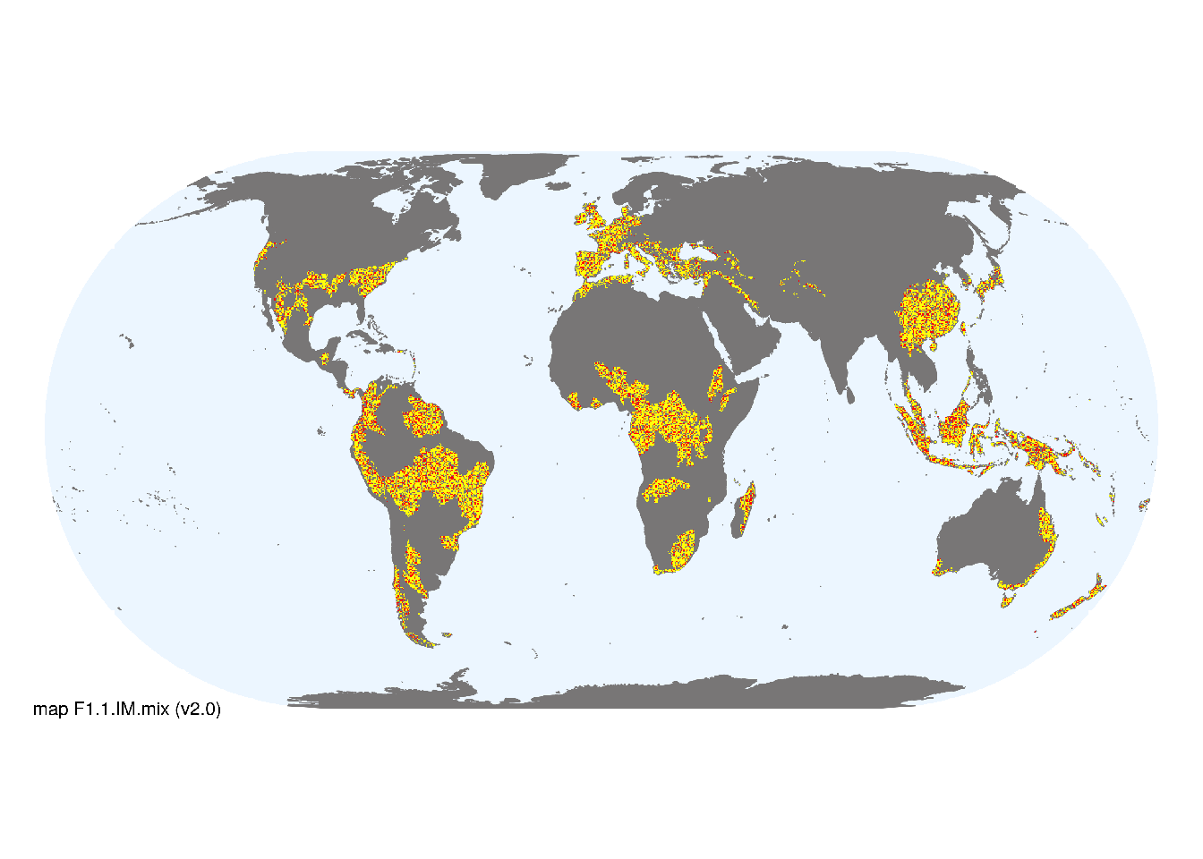
Map description
Freshwater ecoregions (Abell et al. 2008) were initially identified as containing permanent upland streams if: i) their descriptions mentioned features consistent with those identifed in the profile of the Ecosystem Functional Group; and ii) if their location was consistent with the ecological drivers described in the profile. The selected ecoregions were then clipped to exlude cold or dry climates (mean temperature of coldest quarter >0°C, mean annual preipitation >300mm) based on data from Karger et al. (2017). Major occurrences were mapped by intersecting the selected ecoregions with the distribution of 1st-3rd order streams taken from the RiverATLAS (v1.0) database at 30 arc seconds spatial resolution (Linke et al. 2019). The remaining areas within selected ecoregions (excluding freeze/thaw areas) were designated as minor occurrences..
Map code and version: F1.1.web.mix v2.0, available at ![]()
Version history
Profile versions
- v2.1 (2022-04-06): RT Kingsford; R Mac Nally; PS Giller; MC Rains; M Kelly-Quinn; AH Arthington; DA Keith.1
- v2.01 (2021-12-31): NA.
- v2.0 (2020-06-24): RT Kingsford; R Mac Nally; PS Giller; MC Rains; M Kelly-Quinn; AH Arthington; DA Keith.
- v1.0 (2020-01-20): RT Kingsford; RC Mac Nally; DA Keith.
Available maps
Read more details about the current map versions here.
- Web navigation (code: F1.1.web.mix, version v2.0)

- Indicative Map (code: F1.1.IM.mix, version v2.0)
Read more details about older or alternative versions of maps for this functional group.
- Indicative Map: discarded (code: F1.1.IM.alt, version v2.0)
- Indicative Map: discarded (code: F1.1.IM.grid, version v1.0)
- Web navigation: requires review (code: F1.1.web.mix, version v1.0)
- Web navigation: requires review (code: F1.1.web.orig, version v1.0)
- Web navigation: in preparation (code: F1.1.WM.nwx, version v1.0)
- Indicative Map: discarded (code: F1.1.IM.orig, version v1.0)
- Indicative Map: discarded (code: F1.1.IM.mix, version v1.0)
References
Main references
References used in the different versions of the profiles.
- Giller PS., Giller P., Malmqvist B (1998) The biology of streams and rivers. Oxford University Press, Oxford.
- Meyer JL, Strayer DL, Wallace JB, Eggert SL, Helfman GS, Leonard NE (2007) The contribution of headwater streams to biodiversity in river networks. Journal of the American Water Resources Association 43: 86–103.
- Meyer JL, Wallace JB (2001) Lost linkages and lotic ecology: rediscovering small streams. Blackwell, Oxford.
Map references
References used in the different versions of the maps (current and discarded).
- Abell R, Thieme ML, Revenga C, Bryer M, Kottelat M, Bogutskaya N, Coad B, Mandrak N, Contreras Balderas S, Bussing W, Stiassny MLJ, Skelton P, Allen GR, Unmack P, Naseka A, Ng R, Sindorf N, Robertson J, Armijo E, Higgins JV, Heibel TJ, Wikramanayake E, Olson D, López HL, Reis RE, Lundberg JG, Sabaj Pérez MH, Petry P (2008) Freshwater ecoregions of the world: A new map of biogeographic units for freshwater biodiversity conservation, BioScience 58: 403–414. DOI:10.1641/B580507
- Karger, D.N., Conrad, O., Böhner, J., Kawohl, T., Kreft, H., Soria-Auza, R.W., Zimmermann, N.E., Linder, H.P. & Kessler, M. (2017) Climatologies at high resolution for the earth’s land surface areas. Scientific Data 4, 170122.
- Linke, S., Lehner, B., Ouellet Dallaire, C., Ariwi, J., Grill, G., Anand, M., Beames, P., Burchard-Levine, V., Maxwell, S., Moidu, H., Tan, F., Thieme, M. (2019) Global hydro-environmental sub-basin and river reach characteristics at high spatial resolution Scientific Data 6: 283 DOI:10.1038/s41597-019-0300-6
- Messager, M. L., Lehner, B., Cockburn, C., Lamouroux, N., Pella, H., Snelder, T., Tockner, K., Trautmann, T., Watt, C. & Datry, T. (2021) Global prevalence of non-perennial rivers and streams Nature DOI:10.1038/s41586-021-03565-5
- Ouellet Dallaire, C., Lehner, B., Sayre, R., Thieme, M. (2018): A multidisciplinary framework to derive global river reach classifications at high spatial resolution. Environmental Research Letters 14: 024003. DOI: 10.1088/1748-9326/aad8e9
Footnotes
This is the current version available at official site.↩︎